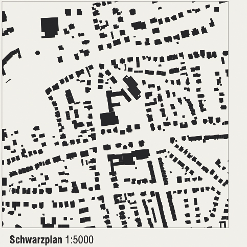
Replacement building Hainberg-Gymnasium | Göttingen
1st prize | Replacement building Hainberg-Gymnasium
Göttingen | In cooperation with Pape+Pape Architects
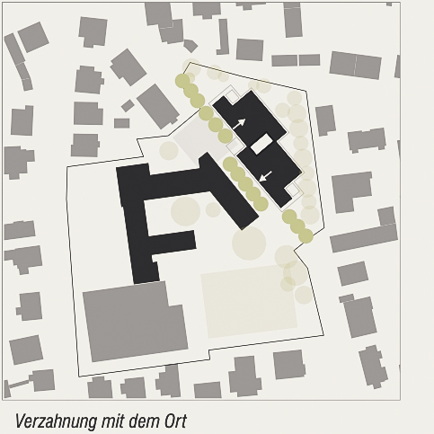
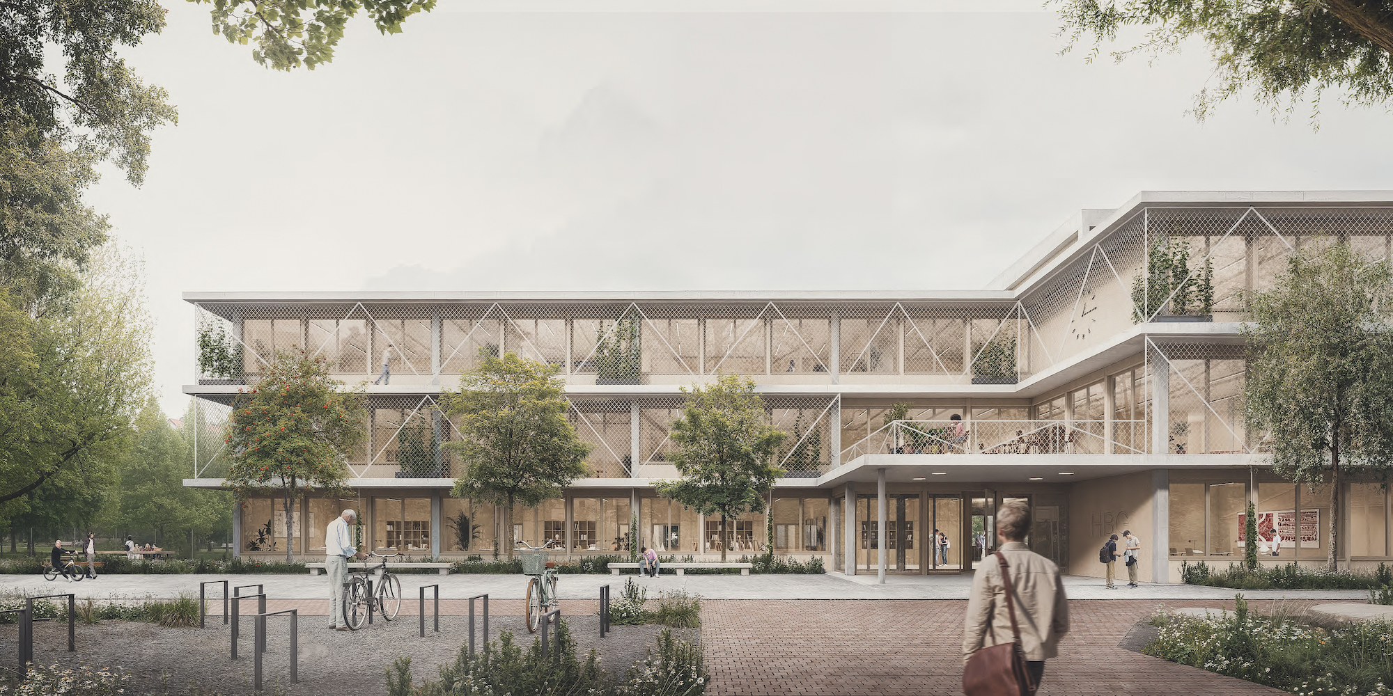
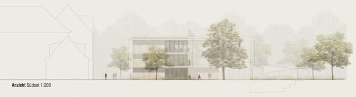
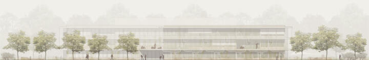
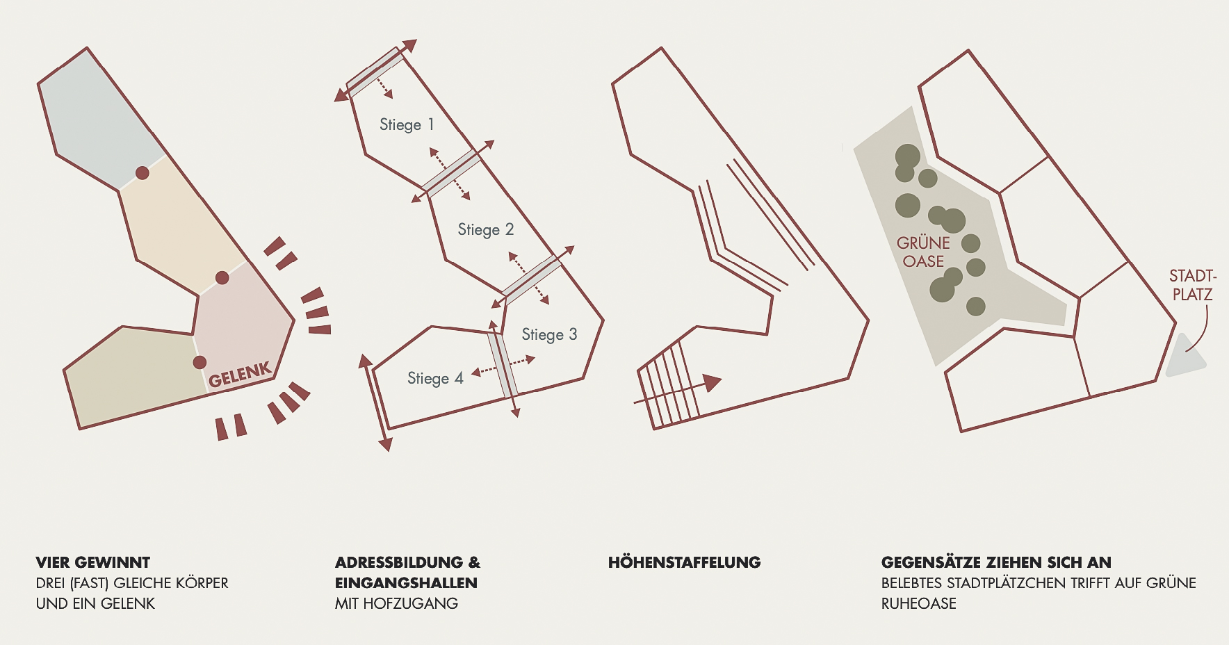
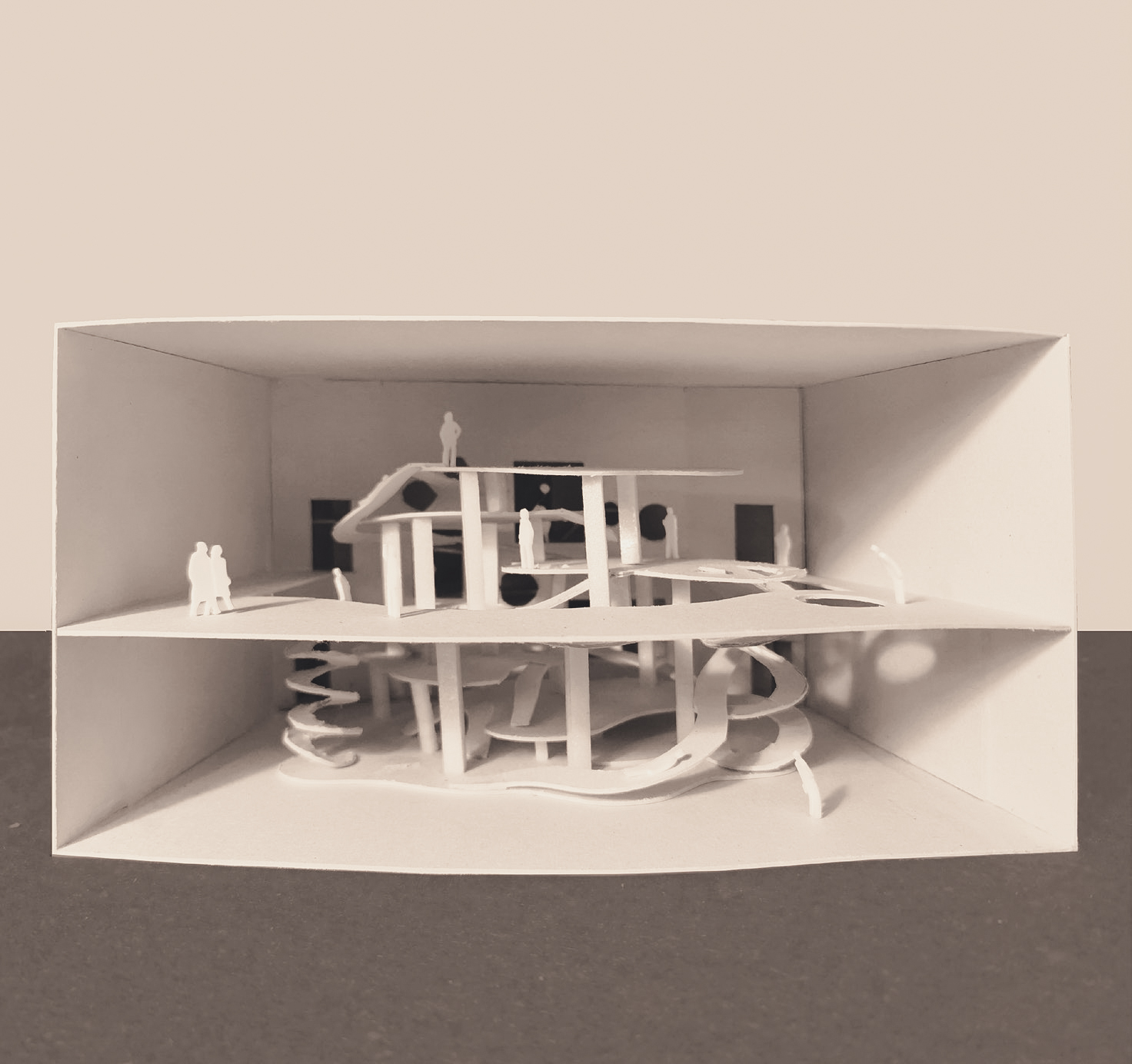
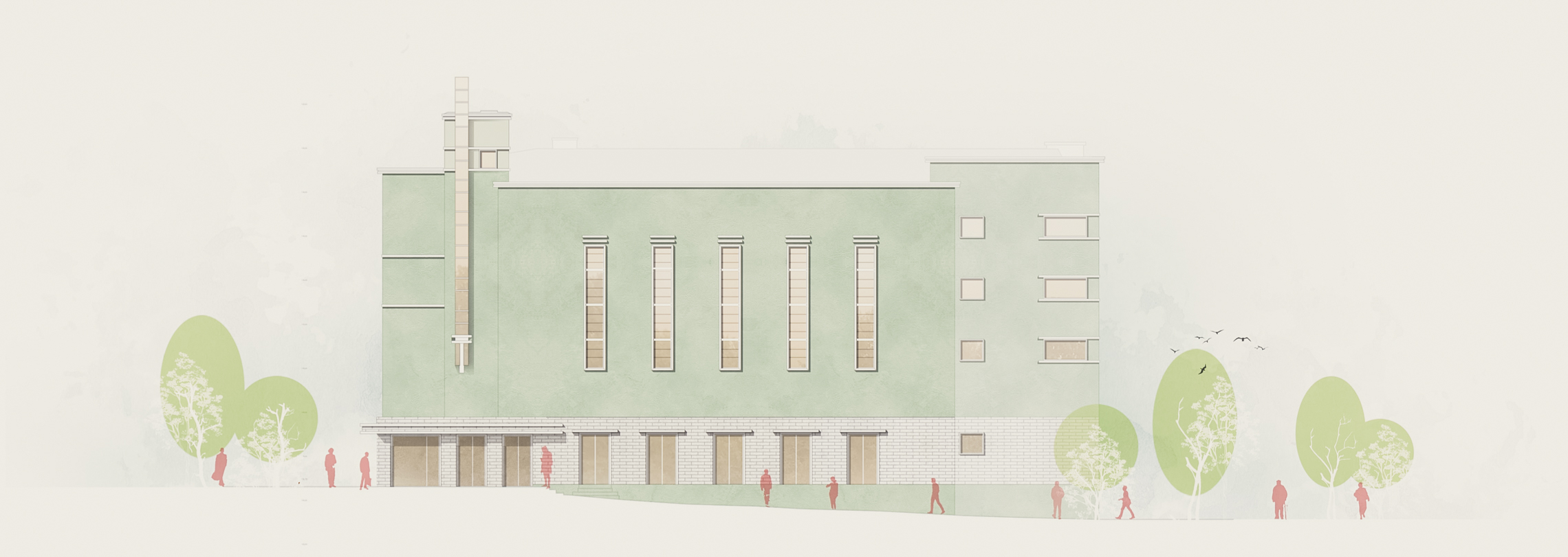
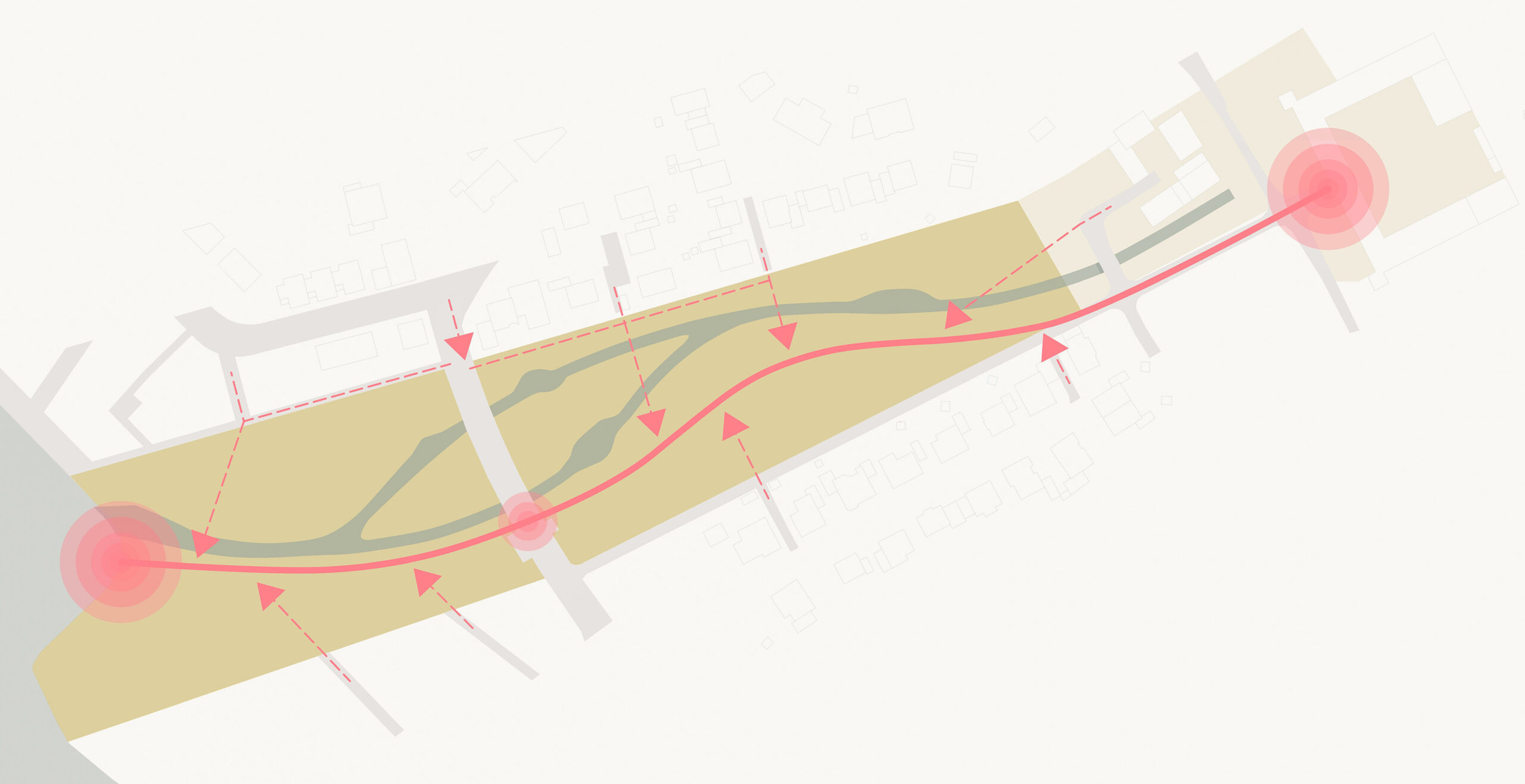
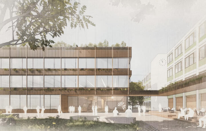
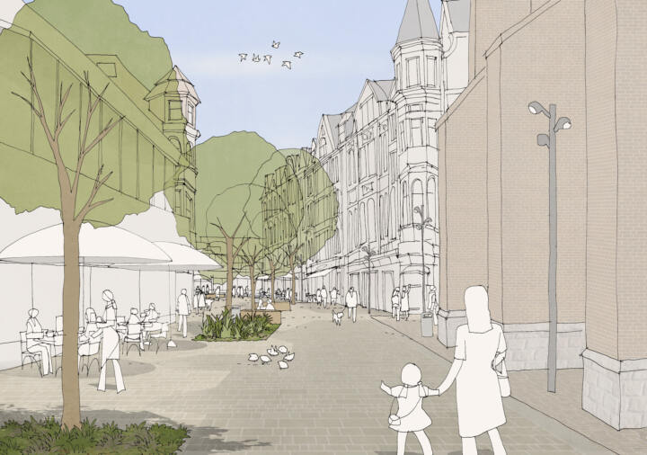
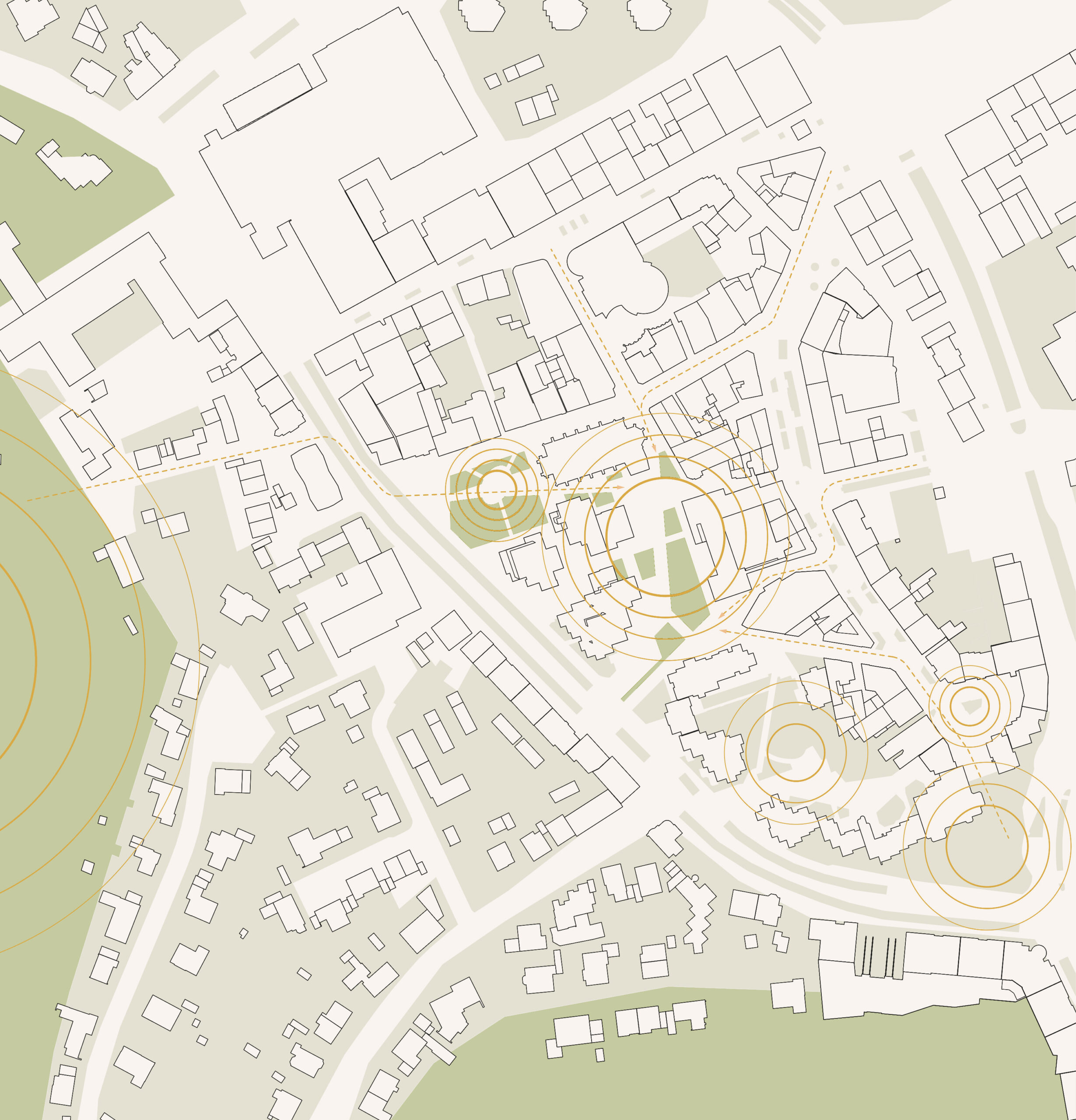
The new replacement building for the Hainberg-Gymnasium and the demolition of the existing school wing from the 1970s open up the opportunity to rethink and restructure the school campus at this location. The aim here is to emphasise the qualities of the school site and to formulate essential functions both in the functional allocation of the buildings to each other and the open space connections in the overall context. With its strong address towards Friedländer Weg, the existing building will continue to be the main focal point of the Hainberg-Gymnasium.
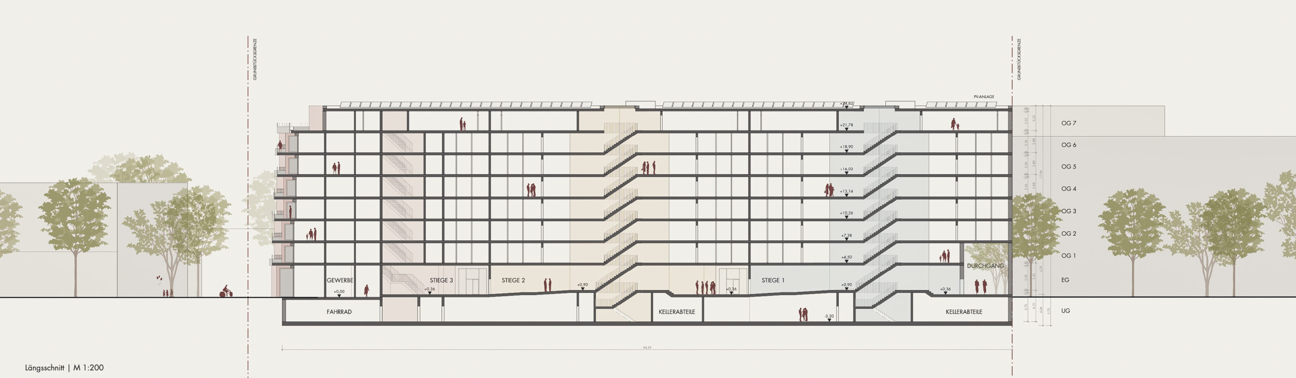
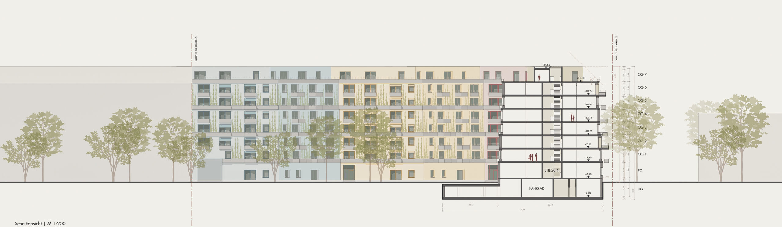
Compact building figure – small footprint – interplay with open space and existing building
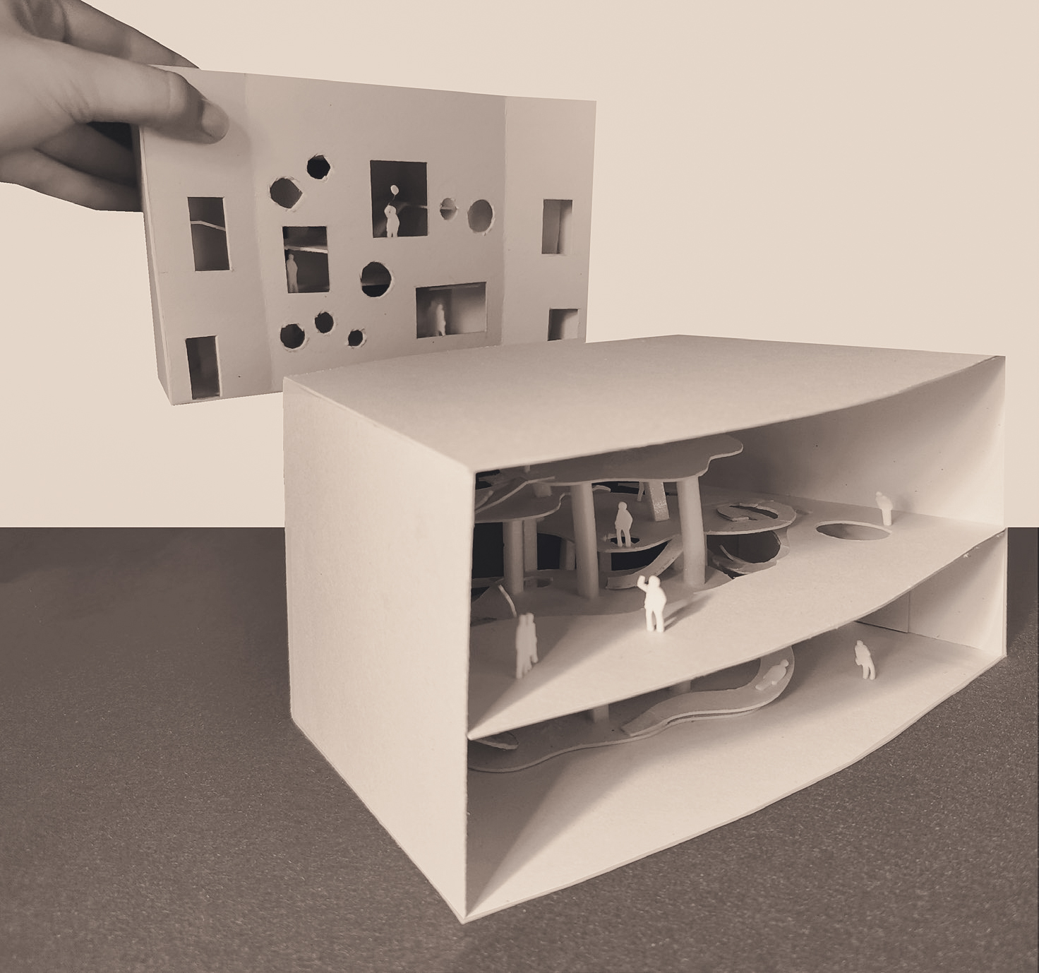
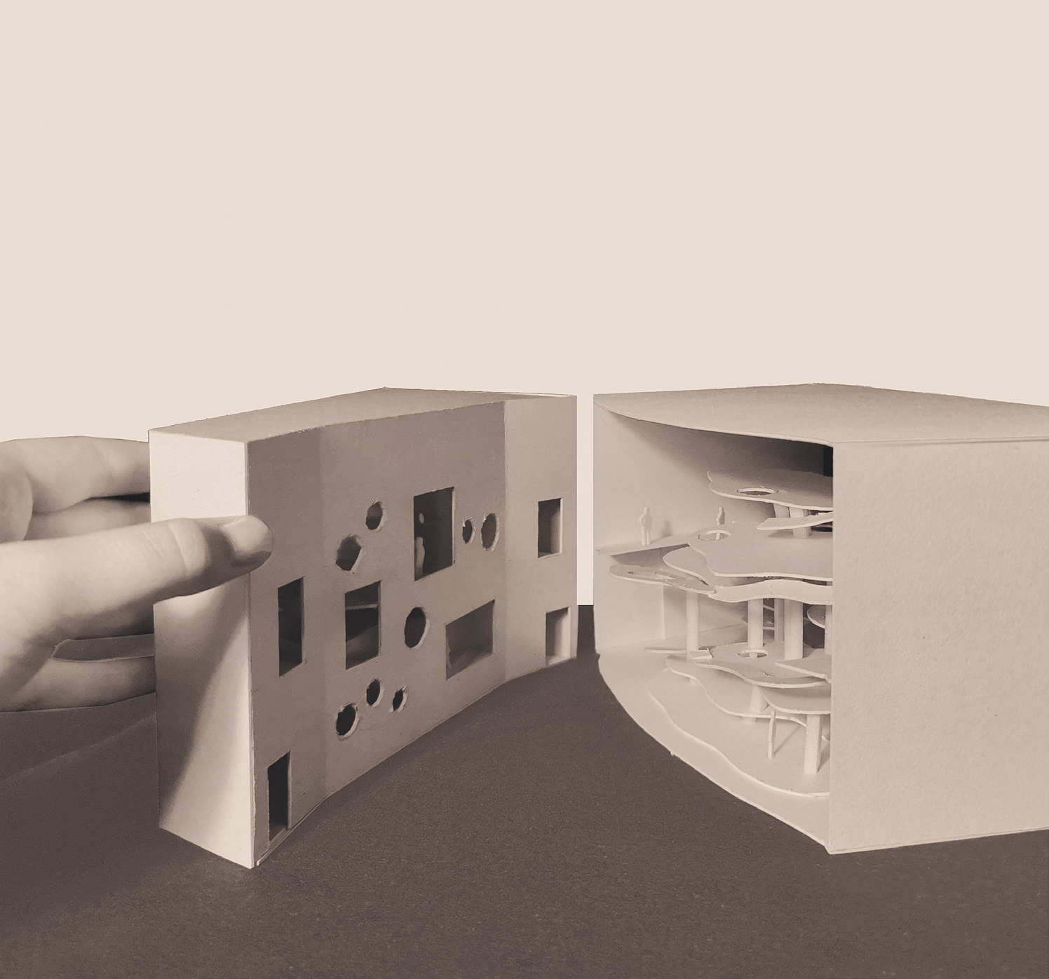
The new building will be developed as a compact 3-storey structure consisting of two cluster building blocks offset from each other to save space. The aim is to integrate the new structure into the existing context in the best possible way, despite the difficult site layout, so that it enters into a dialogue with the existing buildings as well as into a symbiotic interplay with the characteristic trees. In order to optimise the relationship to the surrounding open space, which is of fundamental importance for the learning atmosphere, it is necessary to keep the footprint of the new building as small as possible.
Setting – widening, addressing – caesura as a spatial structure
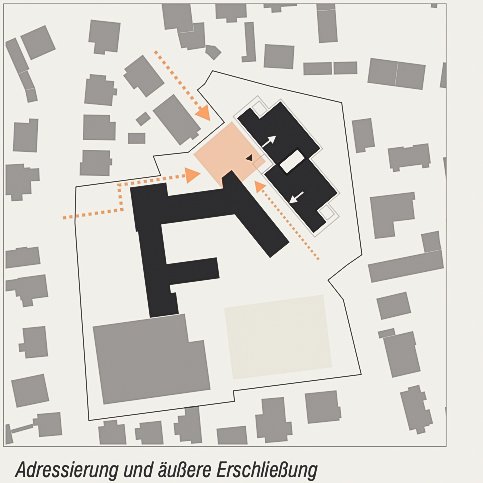
The new building is positioned and modelled on the site in such a way that a new, urban address is created towards the north-western Lohbergstraße.
The offset creates a spatially defined forecourt that forms an inviting entrance to the school grounds at this point and, in interaction with the existing buildings, formulates an open, tangible centre within the school campus. The natural derivation of the entrance from the building offset creates a logical and easy-to-find location for the building entrance.
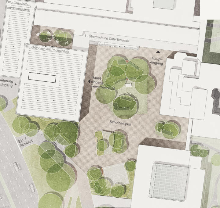
External access
The new building is accessed via the central forecourt, which takes in the access routes via Friedländer Weg (main entrance) and both sides of Lohbergstraße and leads to the central entrance of the new building.
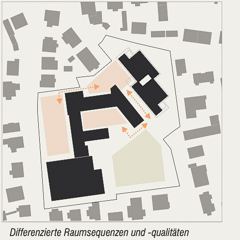
Differentiated spatial sequences
The spatially defined situation opposite the gymnasium creates a deliberate constriction between the new forecourt and the spatial widening in front of the sports fields and the inner schoolyard. The sequence of differently wide and narrow spatial sequences creates exciting, differentiated and varied experience and recreational spaces across the entire campus site.
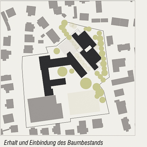
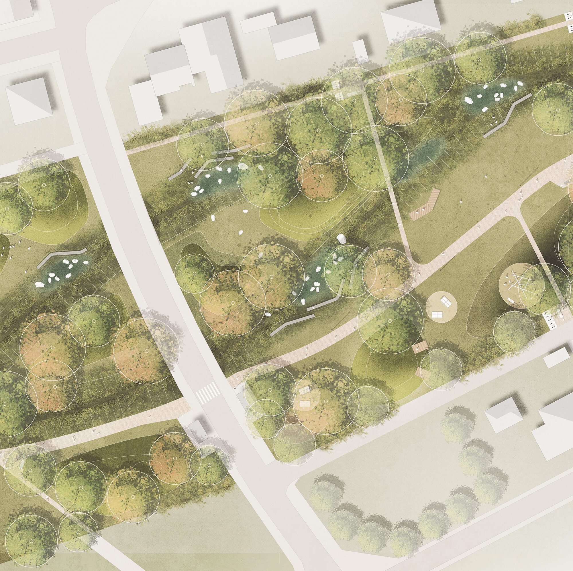
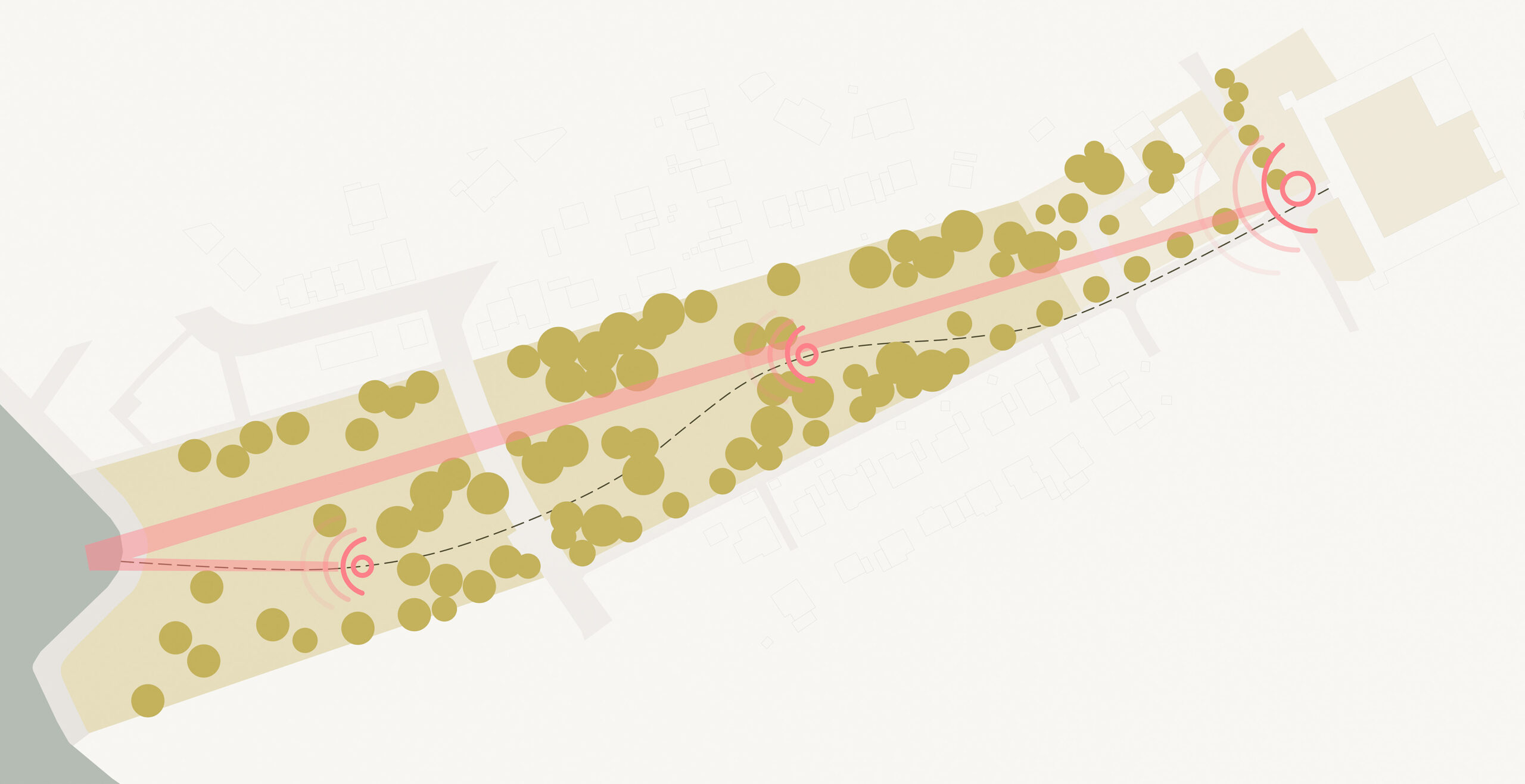
Integration into the existing trees – Zoning of the site – Interaction between building and outdoor space
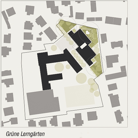
The school site is essentially characterised by its park-like setting with a significant stock of trees. The positioning of the structure creates clear access situations and zoned outdoor spaces that correspond with the use of the building. The positioning of the building structure means that the valuable tree population on the building site can be largely preserved and will continue to characterise the characterful atmosphere of the campus grounds and schoolyards in the future. With its generosity, zoning and the various activities on offer, the outdoor space encourages children to learn and go out, offers exercise and open space, the experience of nature, coolness, play of light and shade.
Experiencing nature – value-added spaces in corners of the site – green learning gardens and ‘green classrooms’
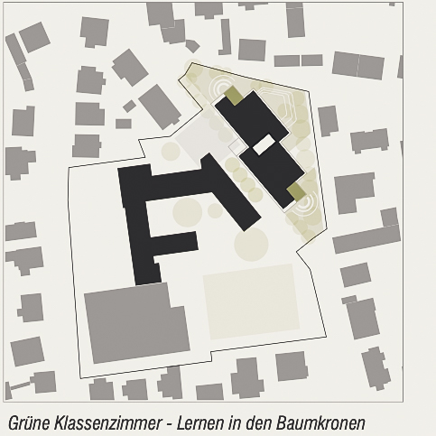
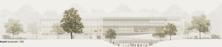
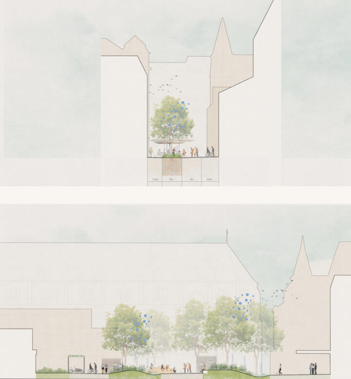
The ‘residual spaces’ remaining in the sloping corners of the site are transformed into valuable learning gardens that are directly linked to the learning clusters or multifunctional zones of the year groups and can be reached quickly from each level via external staircases. The experience of nature is completed by the ‘green classrooms’ arranged in clusters on the transverse sides of the building, which extend into the open space as covered terraces and enable learning at the height of the treetops.
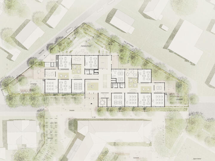
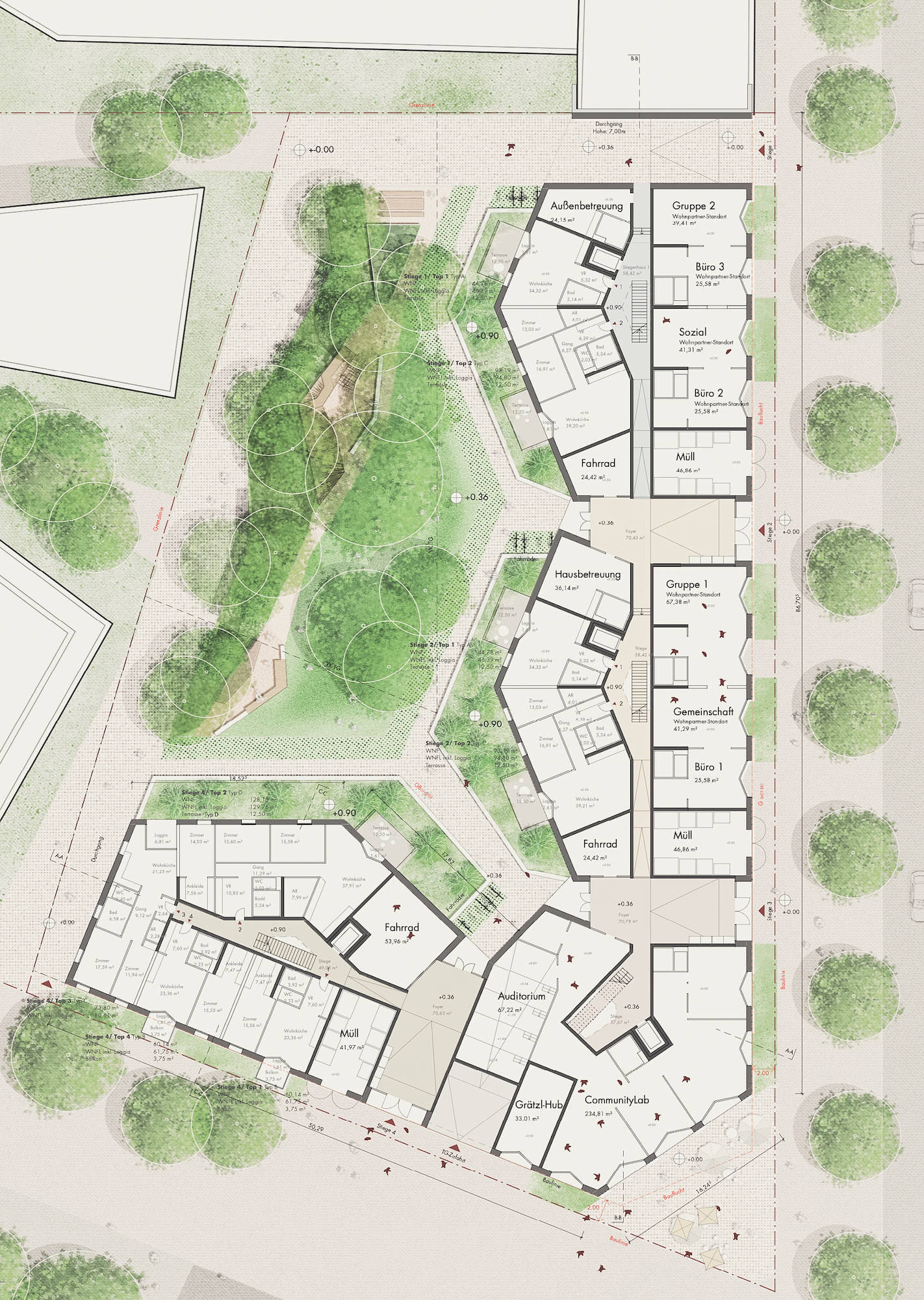
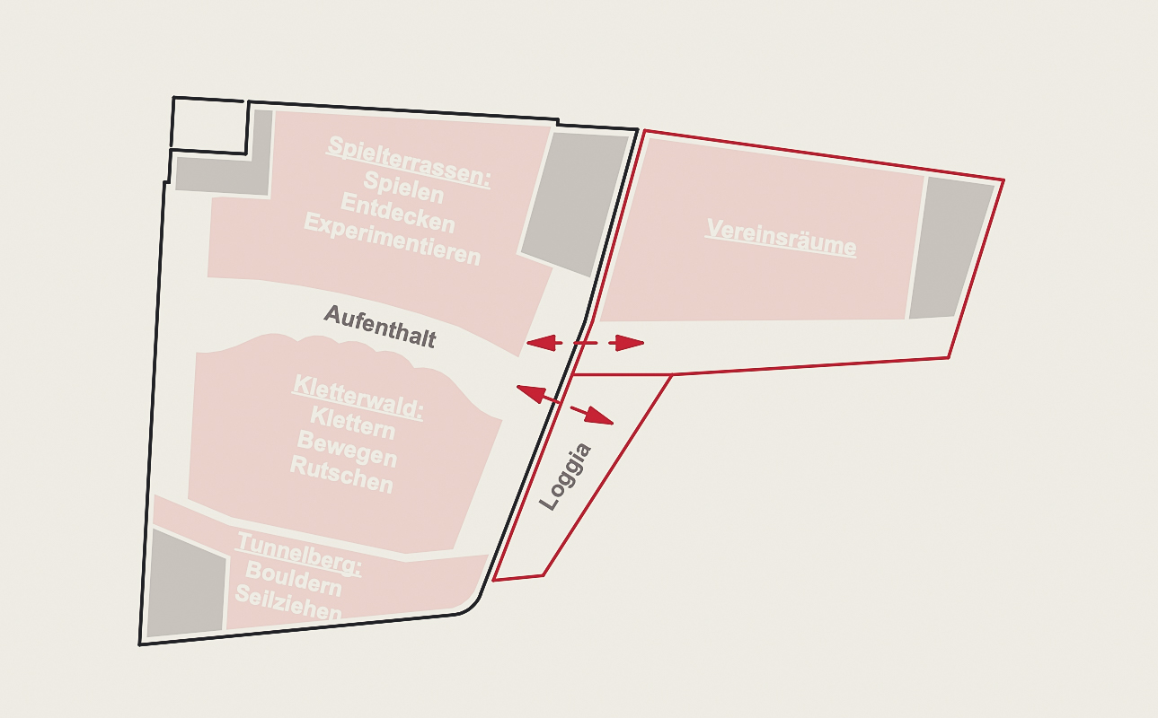
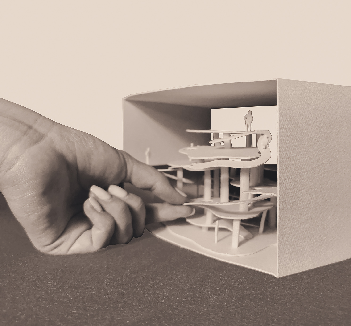
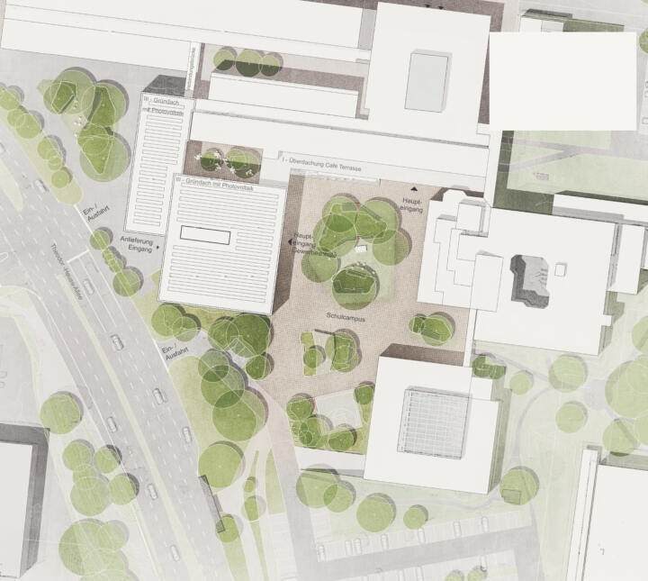
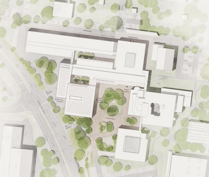
Ground floor – central marketplace, hub and distributor
The spacious foyer forms the central arrival, meeting, learning and break area of the new school building. A cantilevered canopy extends into the outdoor area.
Inside, the spacious foyer connects to the central open atrium with access staircase and the wide open staircase to the canteen (in the basement) and creates exciting visual connections to all floor levels and the neighbouring outdoor areas. The teachers’ station and the counselling office are integrated centrally (and with a view) into the foyer area.
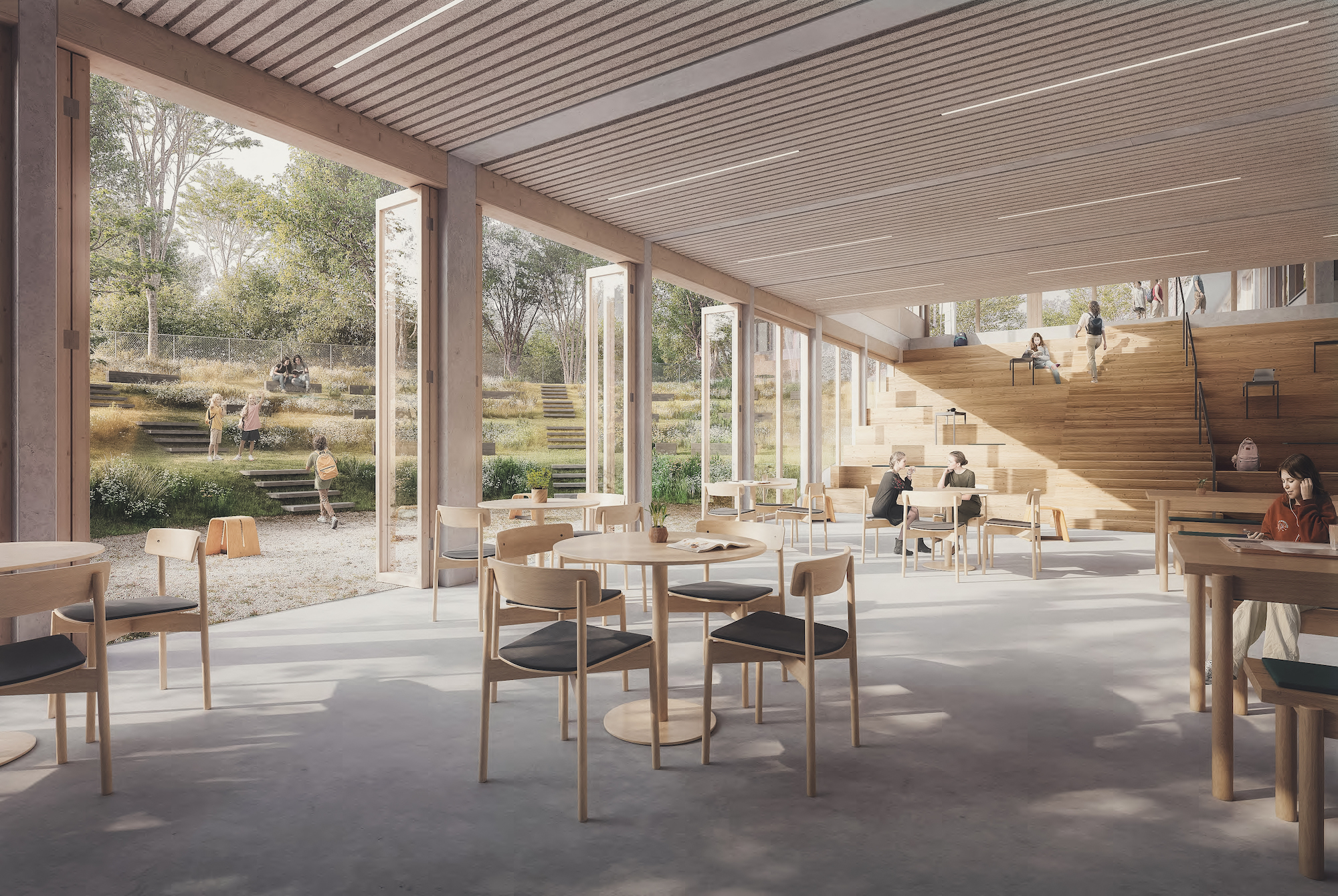
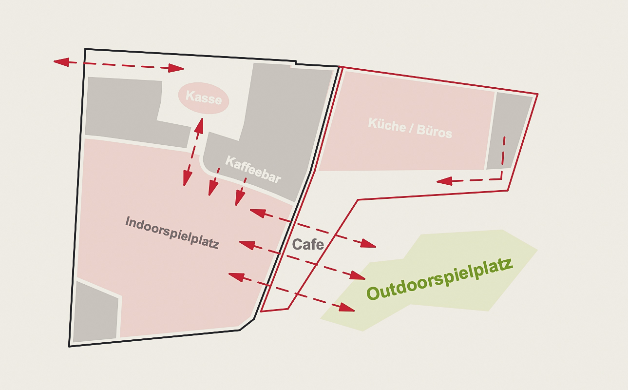
Basement – canteen as a central event location with open-air theatre
Due to the cramped site situation and the added value of the ground-floor outdoor areas, the dining room is located in the basement and designed as a multifunctional dining and event area that can be seamlessly extended into the outdoor space. A wide wooden staircase, which can be used flexibly as a grandstand, study or dining area, leads seamlessly into the foyer and the neighbouring open space on the ground floor.
The cafeteria courtyard is modelled down to the height of the cafeteria with organically shaped, planted grass seating steps – analogous to the course of the open staircase – to create a theatre-like outdoor space with interspersed seating steps. This creates a space that can be used as a dining, leisure and relaxation area as well as an open-air arena (e.g. for concerts and events) and represents a unique added value for the school grounds. The courtyard can be covered with a textile sail to protect it from rain and sun.
The canteen can (but does not have to) be supplied via its own delivery from Kleperweg. In principle, it is also possible to dispense with the external delivery and deliver via the main entrance.
First floor – attractive break and learning zone with an outdoor connection
The central circulation area on the upper floor is also developed as a multifunctional area with an outdoor connection, which extends through the building in a transverse direction. This allows the area to be used flexibly as an interconnected break, exhibition, leisure and self-learning zone with two outdoor terraces. If required, a separate multifunctional room (01.04), which can be divided by a mobile partition wall system, can be separated from the area on each of the outer sides.
Double year clusters with reference to open spaces
On the ground floor and on the first floor, there will be a double-year cluster accessible from the central access zone. The clusters are grouped around open, bright self-study zones, which are connected to the open space via the open and transparent group and multi-purpose rooms and lit via openings in the classroom walls.
Green classrooms
In addition, each cluster has its own terrace overlooking the open space (green classroom with a view of the treetops) and access to the neighbouring learning garden.
Open space
The skilful urban planning of the new building on the tightly dimensioned site creates a campus with a clear sequence of open spaces that are finely differentiated in their relationship to the learning activities. In addition to the learning gardens and green classrooms on the ground floor and first floor, which are directly assigned to the learning landscapes of the new building, the canteen is extended into the open space by a sunken garden with a terrace area and grass terraces modelled like grandstands with benches. The small embankments are planted with a robust, insect-friendly mixture of perennials and grasses, creating a year-round flowering canteen garden with a high quality of stay.
A seating step system, which also integrates barrier-free access to the lower level, equalises the different levels between the retained large schoolyard and the new sports facilities.
The area freed up by the demolition will provide sufficient space for a multi-purpose all-weather pitch, a long jump and high jump facility, callisthenics equipment and a bouldering wall – an offer that will be further differentiated in discussion with the users.
All roofs will be designed as biodiversity roofs with maximum retention. Where soil conditions permit, rainwater from the roof and paved areas will be infiltrated.
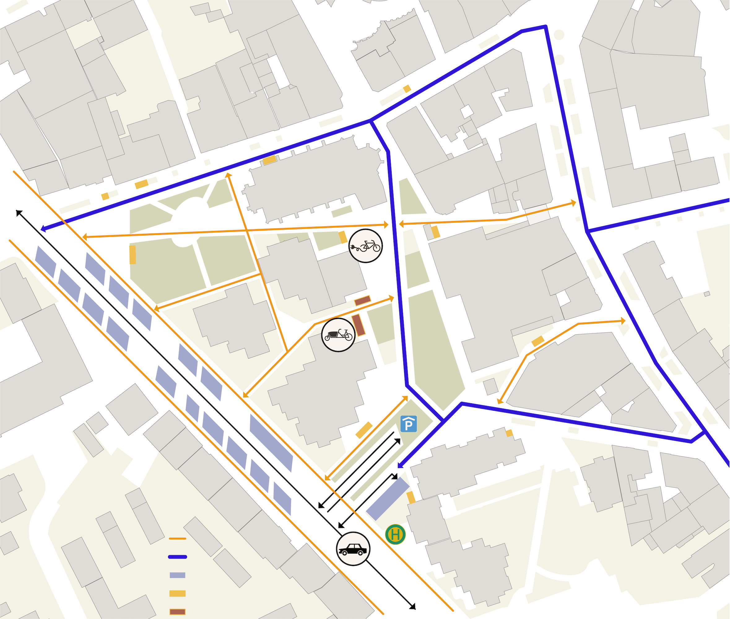
Mobility
The mobility requirements are fully mapped on the competition site. Additional services such as a bike safe and e-charging stations for cars and bicycles are also proposed.

Northwest railway station building site 9 | Vienna, Austria
3rd prize | Nordwestbahnhof building site 9
Vienna, Austria | In collaboration with Schneider+Schumacher
Concept
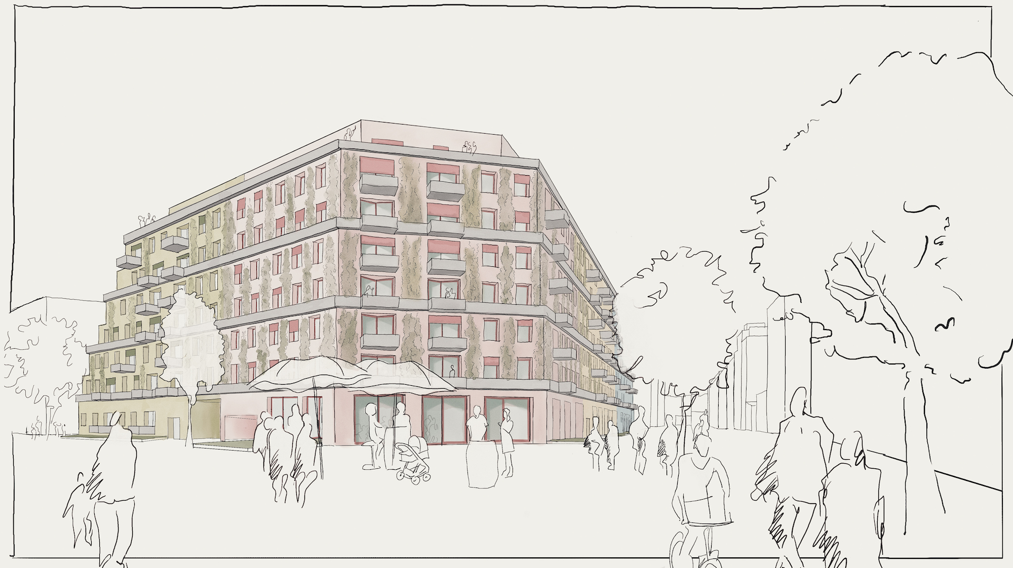
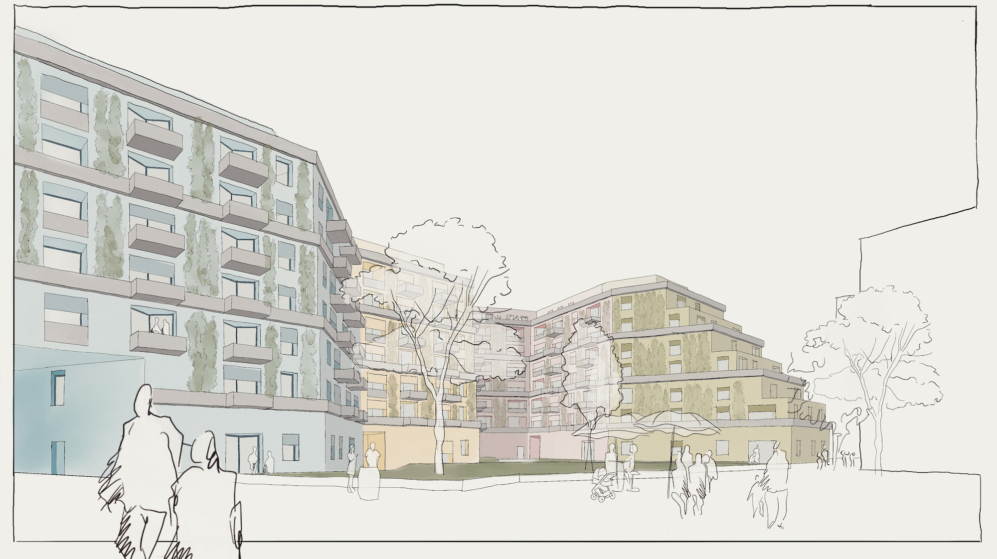
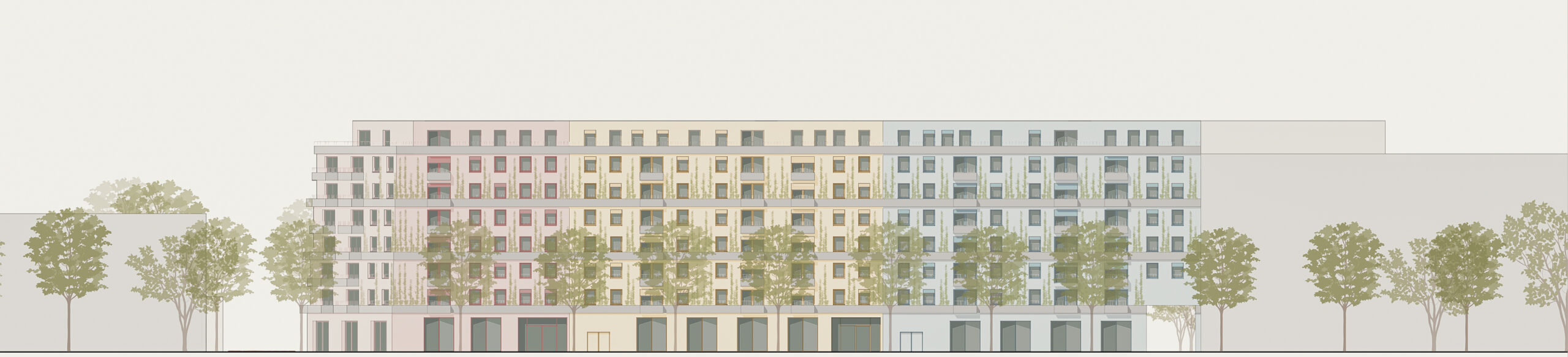
The ‘Glück am Gleis’ design for the Grünhof combines ecological sustainability with well thought-out design elements to create a sustainable and liveable residential environment that guarantees both public and private space with all the nuances between the two poles and takes ecological and social aspects into account in a balanced way.
The overarching connecting path between the building plots in a N-S direction is extended towards building plot 9 to form a play promenade, which is demarcated from the semi-private inner courtyard by a seating edge and loose shrub planting. In this way, the path becomes its own play and meeting area across blocks with bench elements on the raised seating edge, some of which are covered by rainproof pergolas.
Open space concept
The inner courtyard is a semi-public area dedicated to the residents, shielded from the play promenade by shrubs. Surrounded by trees, the large meadow offers space to play and relax. The play equipment is grouped together as long linear play equipment and positioned on the west side facing the promenade so that it takes up as little space as possible. The areas for the youngest and older children are discreetly separated from each other. They each have seating – some with tables – for the parents. Further table/bench combinations are positioned away from the play sculpture so that children can withdraw.
In addition, an area for urban gardening has been integrated into the inner courtyard as an option to give interested residents the opportunity to grow vegetables and herbs on a communal plot, but on their own raised bed.
The private patio areas are separated from the inner courtyard by a planting area with a mixture of low flowering shrubs and tall, robust grasses and perennials, so that privacy is maintained at all times without the need for hedges. An upstand between the semi-public courtyard and the planting of the private terrace areas also ensures a clear separation of the areas.
The private access routes are designed in such a way that they not only provide access to the flats, but can also serve as fire service access and set-up areas.
A central element of the structural design is the generous greening of the façades, in which – depending on the exposure – a selected range of robust climbing plants is used to improve the microclimate and contribute to the natural cooling of the buildings through both the shading and the evapotranspiration of the climbing plants. The greening of the façades also creates an attractive, green appearance and supports biodiversity.
To promote natural water circulation and prevent flooding, the roof surfaces are designed as retention roofs. The focus of this greening is on optimising biodiversity for the site. The degree of sealing of the open spaces was deliberately kept as low as possible. Permeable surfaces enable efficient infiltration, and the play area is modelled accordingly so that it can also serve as a temporary retention area.


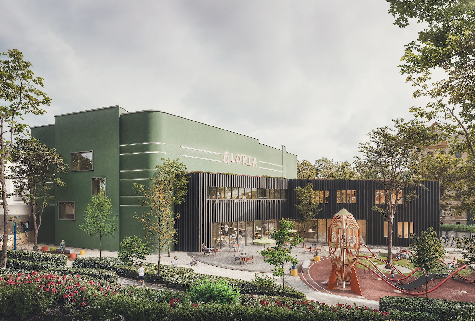
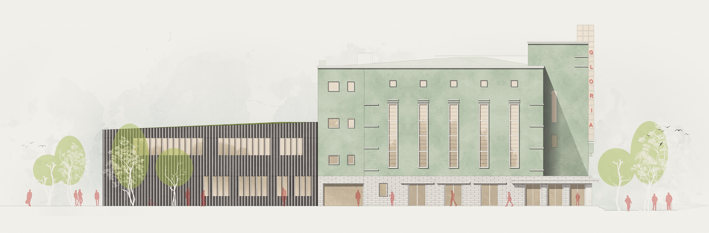
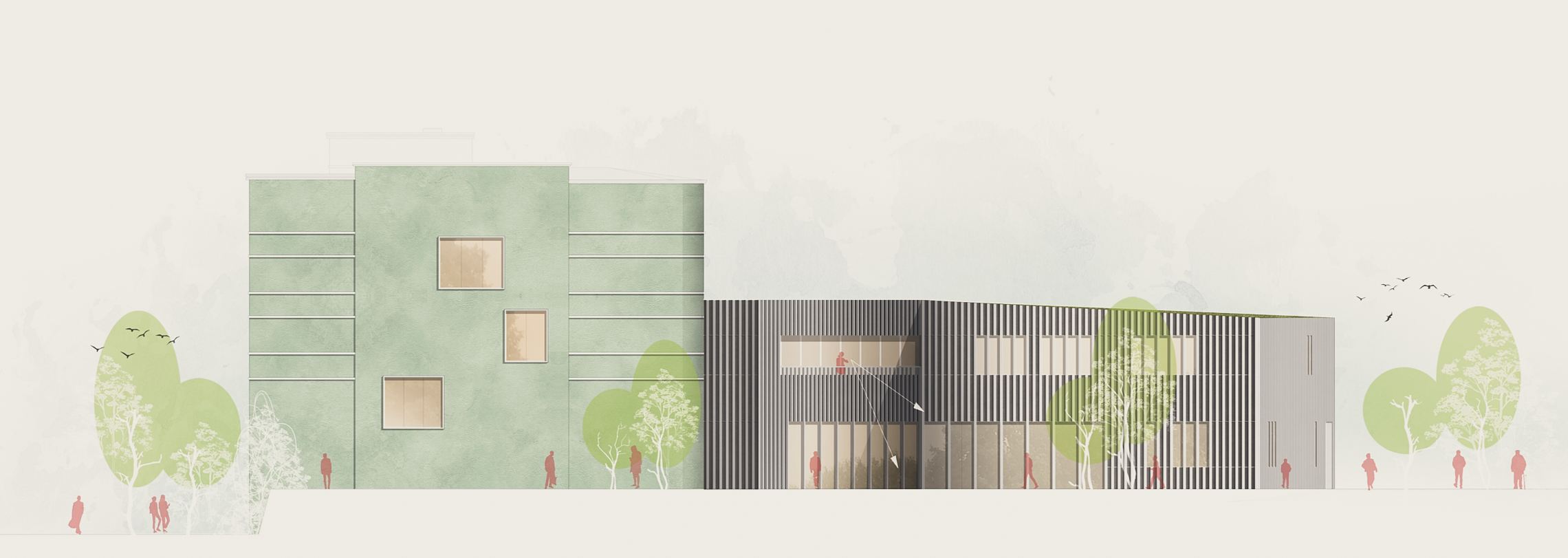
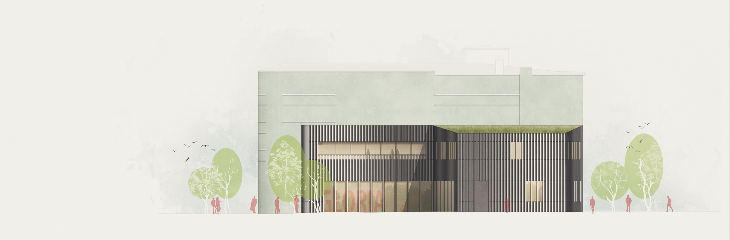
Former Gloria-Palast cinema | Weißenfels
3rd prize | Former Gloria-Palast cinema
Weißenfels | In collaboration with ATELIER 30 Architects
Design idea, guiding principle
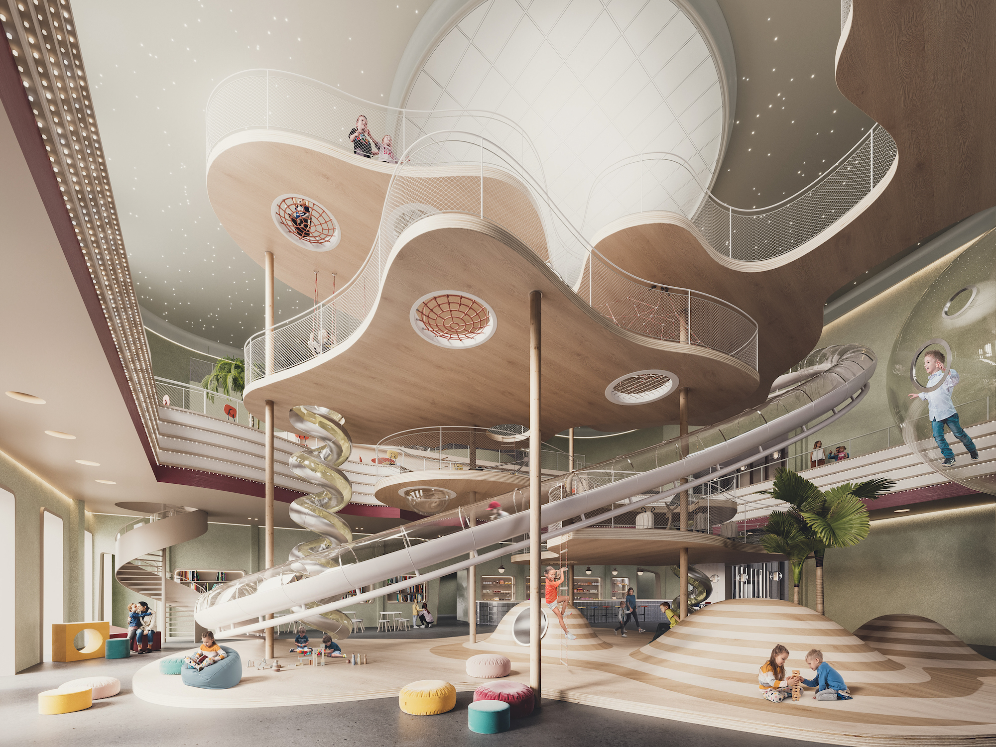
The planned refurbishment of the Gloria-Palast offers the opportunity both to preserve the listed building fabric and to restore the historic cinema architecture, as well as to use the historic building for a new purpose with the planned conversion, which will enable the economic and functional maintenance of the building. The renovation of the existing building aims to expose and refurbish the existing building fabric. The design intention is to restore the structure and surfaces as closely as possible to the original 1928 cinema architecture in terms of colours and materials. The fixtures and play equipment required for the intended use as a playground are to be incorporated into the refurbished building as furniture and play sculptures, creating a varied and attractive play landscape with flanking catering facilities. All areas of the building will be playfully integrated. The spectrum ranges from climbing, sliding and creative play to experimentation and a gaming area. The former administration building will be replaced by a new building in which the necessary additional functions will be located. With the direct connection to the existing building, a location with many possibilities is being developed, while at the same time the new building represents the connection to the outdoor play area.
Outdoor facilities / outdoor play concept
The concept of different levels of experience is taken up again in the outdoor facilities. The open space is divided into two clearly defined zones with different play and recreational opportunities. In the south, in contrast to the railway embankment, a green fringe of trees and shrubs, an adventure jungle of shrubs and hedges is created, which takes up the topography of the site and slopes slightly from south to north. A clear edge defines the remaining height difference of approx. 1 metre and the transition to the adjacent experience level, which is at building level. An outdoor catering area and three play bubbles are created here, which are clearly recognisable thanks to their uniform circular shape and offer an intimate play atmosphere. Climbing, bouldering and trampoline jumping facilities are located here and complement the informal appropriation and play opportunities of the adventure jungle with further cross-generational offers.
A sculptural climbing frame accentuates the central play bubble in the centre of the open space. As a connecting element between the outdoor catering area, adjacent to the building, and the play area, it also assumes a guiding function for visitors. A viewing tower on the boundary between the upper and lower experience levels picks up on the special theme of stairs and ups and downs for the cinema. Exciting views of the railway and the Saale river are provided here, creating a visual link between the different experience levels. Steps and seating elements offer the opportunity to linger, while new tree plantings provide shade and a spatial organisation of the outdoor area. A paved path surface in the outdoor catering area and in the north-eastern access route does justice to the high frequency of use of the site. EPDM as a fall protection surface marks the play bubbles. The colour of the paved surfaces supports the special effect of the green façade of the Lichtspielhaus. The high proportion of otherwise unpaved surfaces ensures a pleasant microclimate and meets the current requirements for a sustainable and climate-friendly open space.
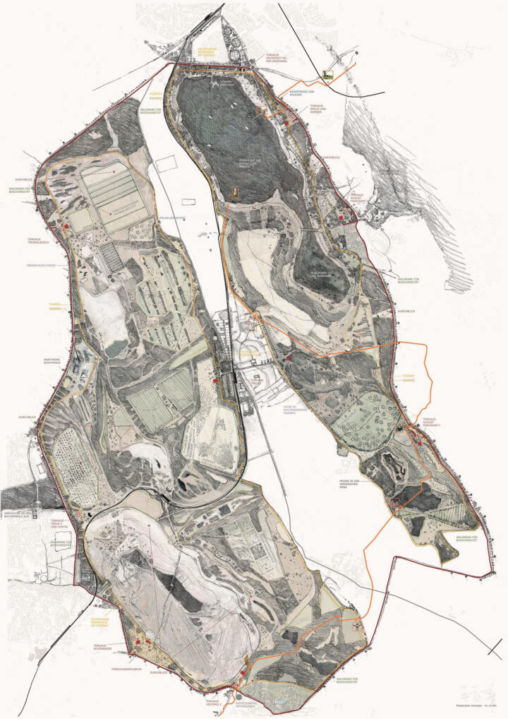
Transformation of the Helmstedt Mining Area | Helmstedt
Recognition | Transformation of the Helmstedt Mining Area
Helmstedt
In collaboration with WELP von KLITZING
BETWEEN ELM AND LAPPWALD – THE OPEN-CAST MINING OF THE FUTURE
ADMIRE – PRESERVE – PROCESS – EXPLORE
Wonderful landscapes and mystical places
Mystical places, archaic structures and overwhelming nature characterise the Helmstedt district. However, the special opportunity offered by the area lies not in restoring what was once there, but in accepting what exists as a document of time and utilising its unique qualities. The place tells its own story. Natural, process-oriented sequences and changes in the landscape are integrated into the concept.
Through targeted interventions, different places with their individual characters are highlighted and brought to life. Unspoilt areas are reinforced and further developed. In line with the cautious design approach, the open-cast mining lakes are filled exclusively with groundwater and precipitation water. The very slow process is an expression and quality of this approach.
The frame
The boundaries of the area are made visible and tangible by wind turbines, avenues, promenades and forest edges. This allows visitors to experience the dimensions of the place and preserves its history. As with the frame of a picture, the content becomes something special, something precious.
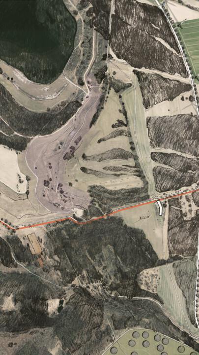
Country roads 244 and 245a become a ring road. Species-rich forest edges are developed between the abandoned landscapes of the open-cast mine and the ring road.
The combination of wind turbines standing at the frame and clearly marked cycle paths on the ring road emphasises the enclosure as an artificial element.
Paths and trails
A delicate network of paths and trails criss-crosses the entire area. Circular trails enclose individual sections and frame them. Cycle paths and footpaths circle the two large mining areas, while footbridges provide access to sensitive or dangerous areas.
Nature is reclaiming the area – a dynamic process controlled by the nature of the substrate and the respective site conditions. On barren, nutrient-poor soils, pioneer plants such as mosses, lichens and birches initially prevail, while willows and alders thrive in more humid areas. Sunny slopes favour the development of dry grasslands with rare herbs and grasses, while species-rich wetlands develop in sheltered hollows. Natural succession processes create a mosaic-like landscape of diverse vegetation zones, which provide habitats for a variety of animal species and transform the area into a unique natural space.
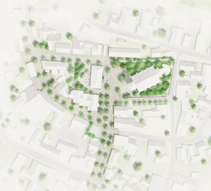
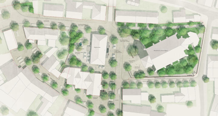
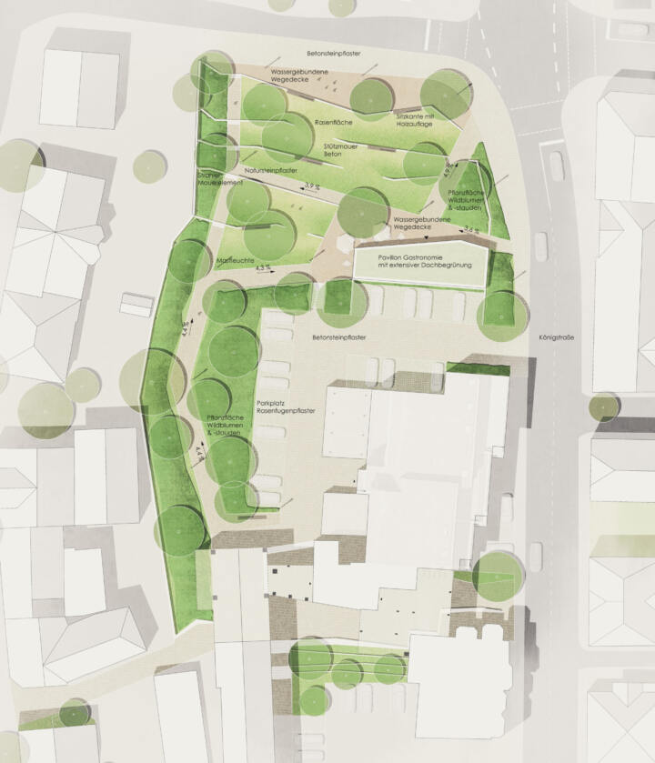
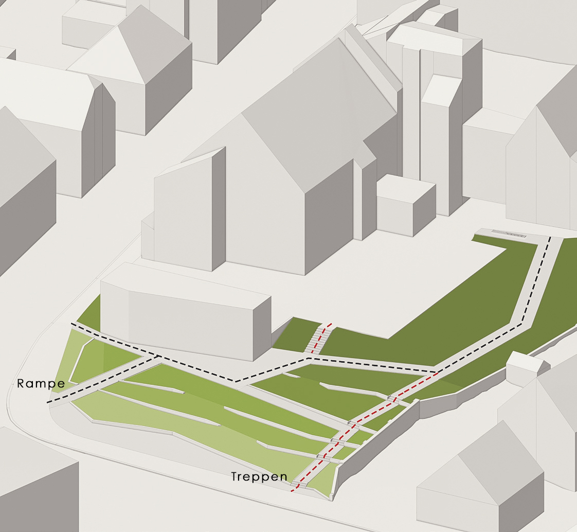
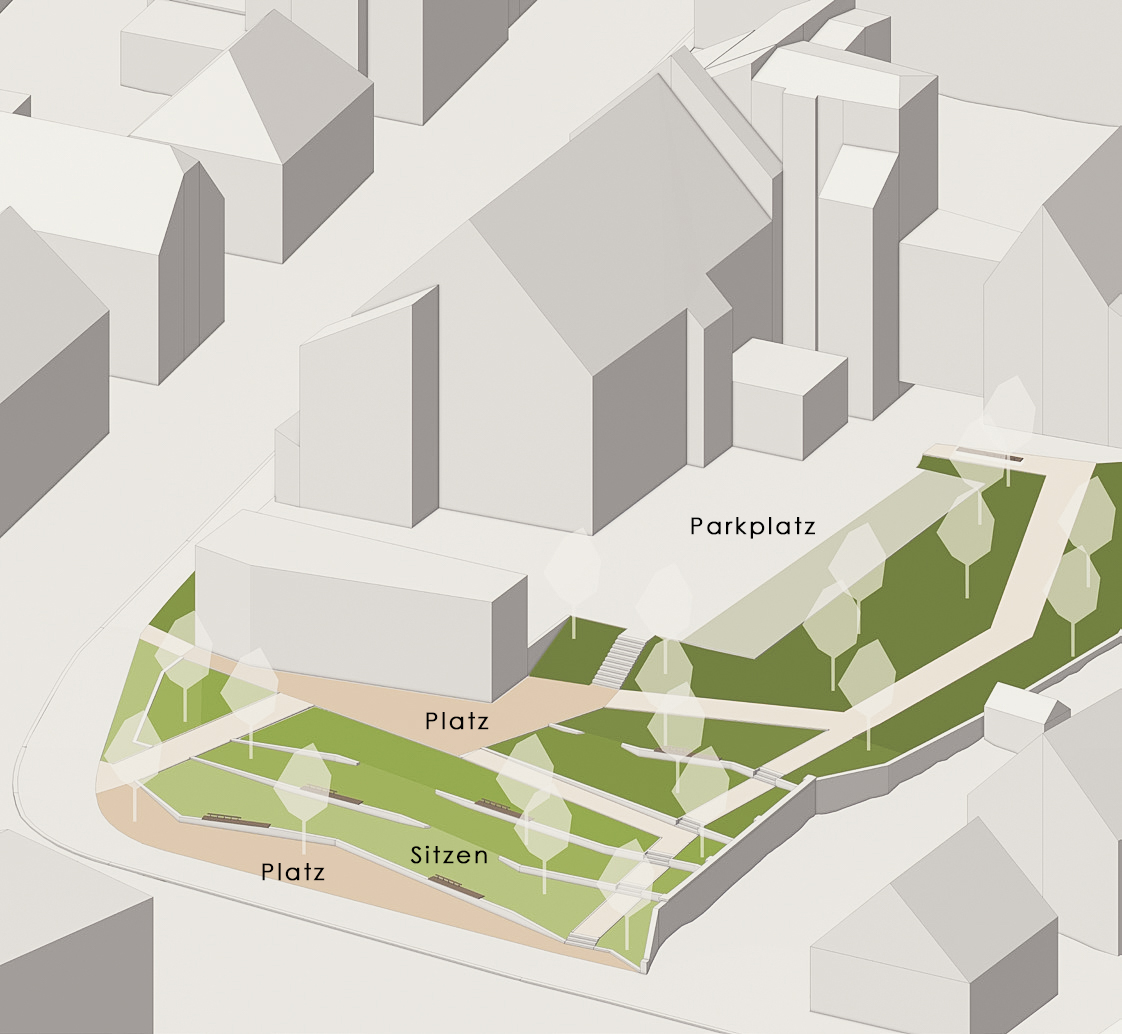
City Centre | Borgentreich
3. Prize | City Centre
Borgentreich
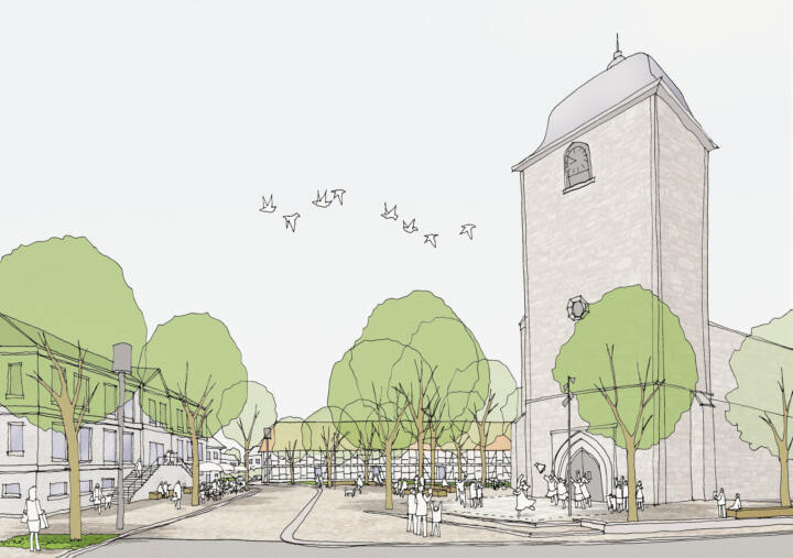
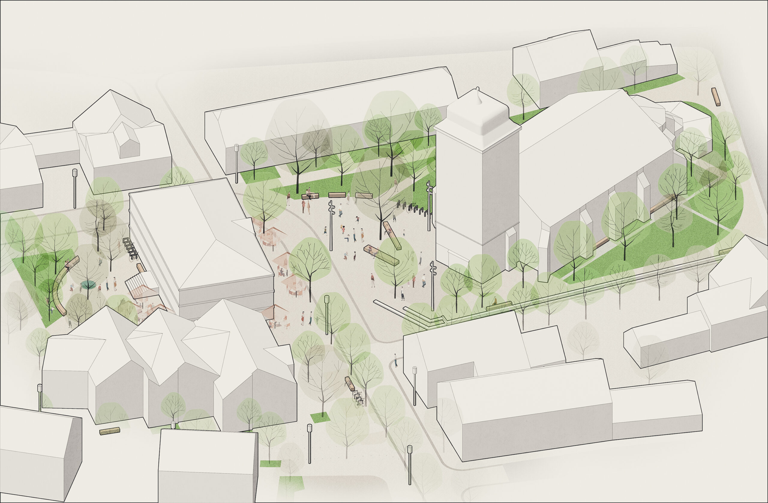
A new centre for the organ city
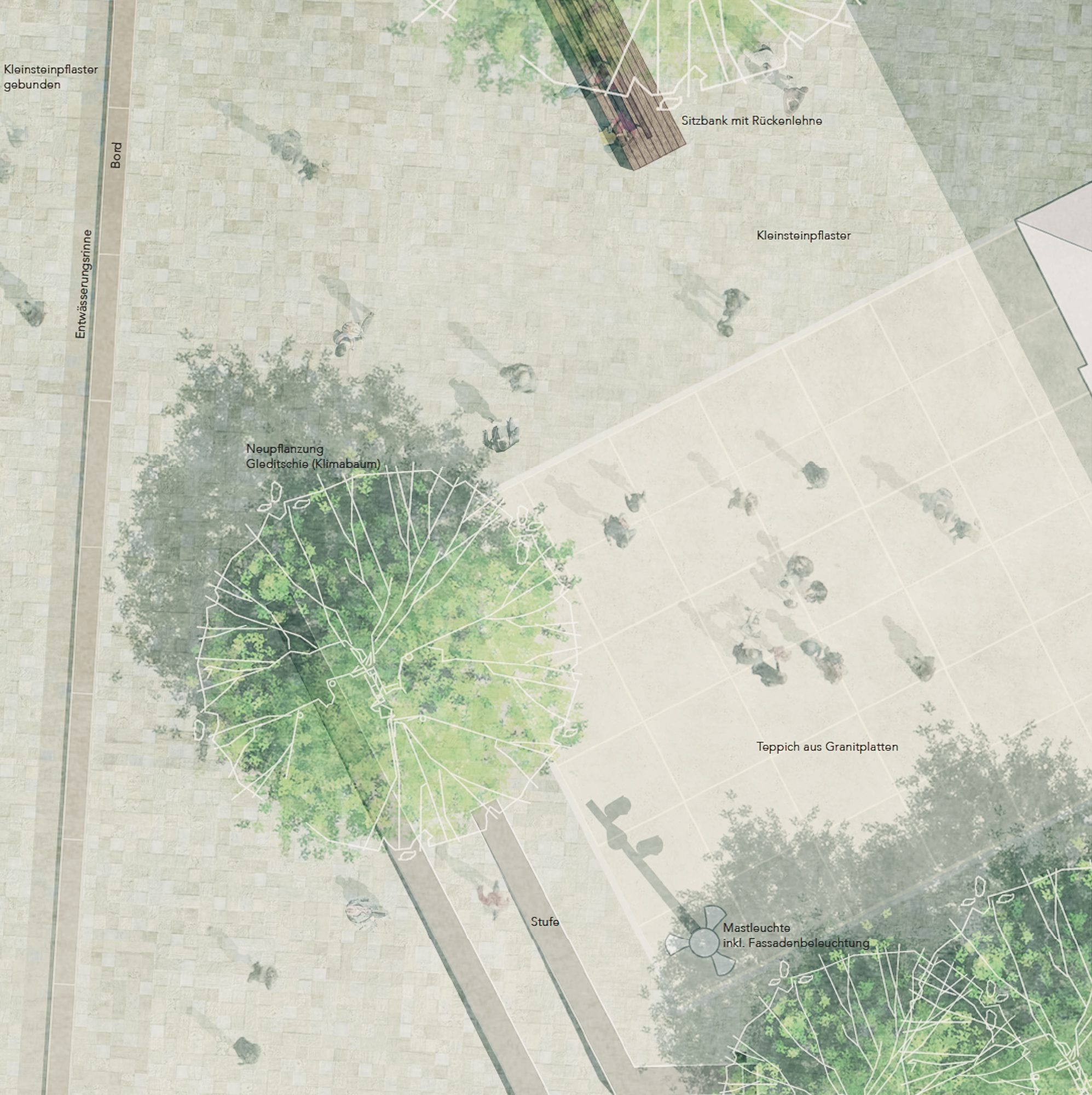
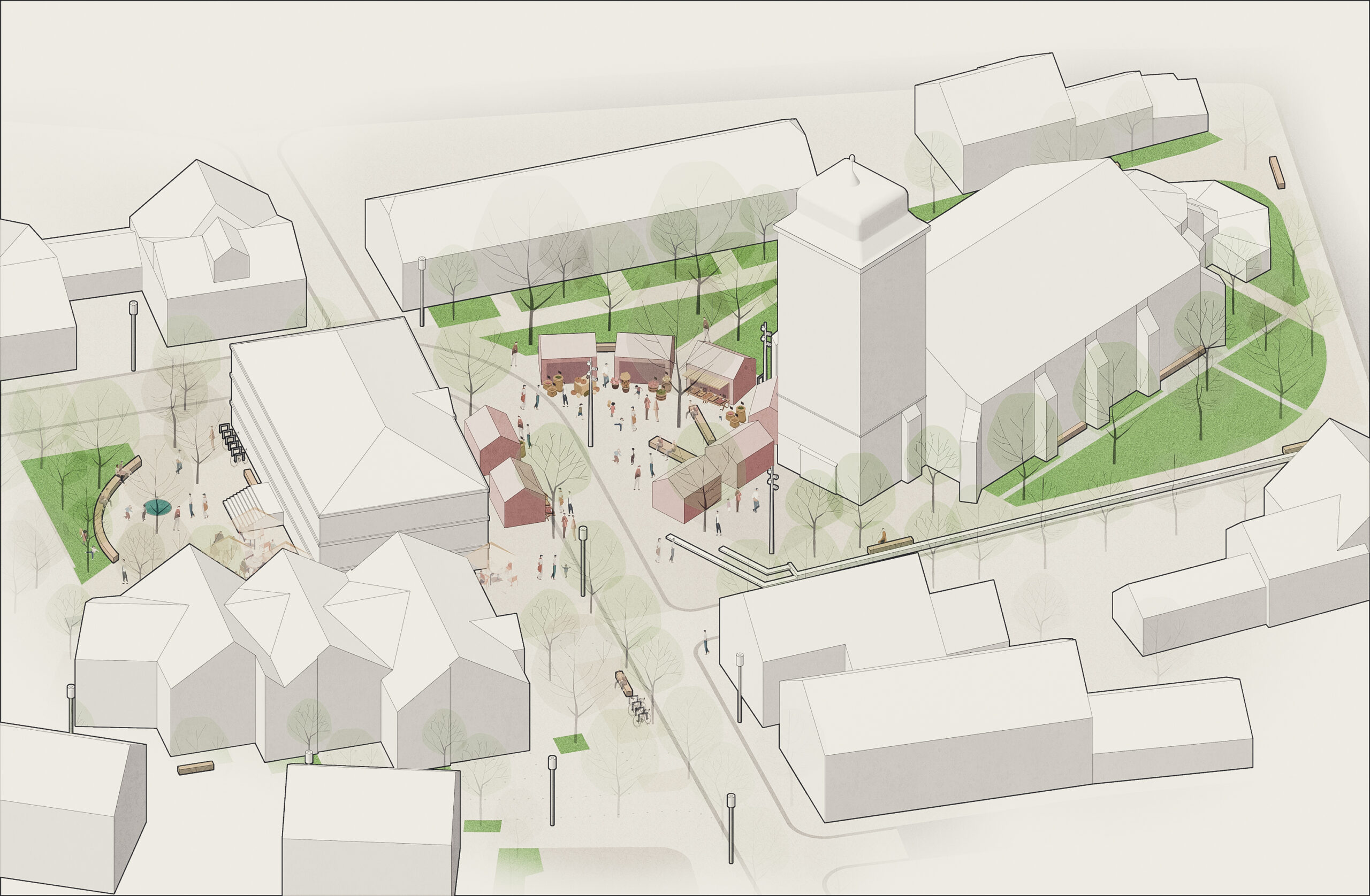
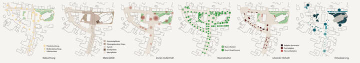
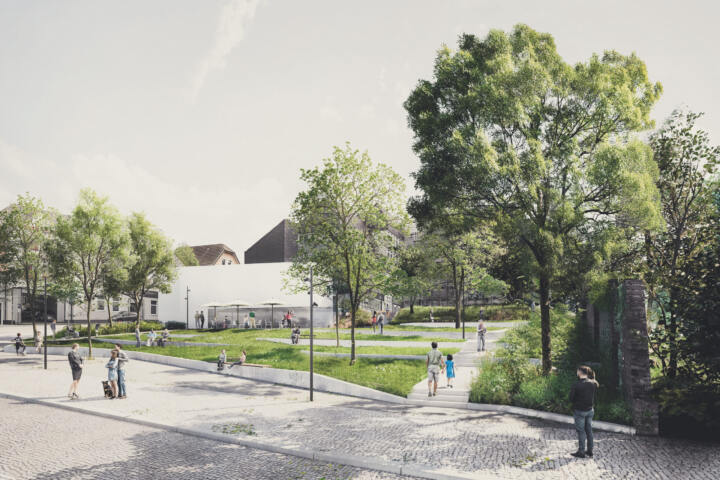
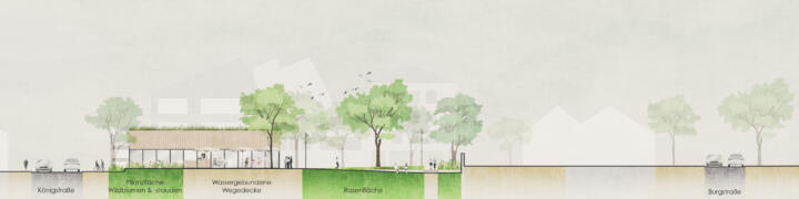
The design concept for the town centre area of the organ town of Borgentreich envisages an upgrading of the historically significant ensemble of church, organ museum and the surrounding half-timbered houses. A strong, green framework will create a central square where the church and the organ museum are located, thus creating a new centre that is appropriate to the location. This square offers space for intergenerational stays, festivals, markets and meetings in front of the church. Appropriate shading and evaporation areas and the use of light-coloured materials will create a climate-adapted urban space.
In the existing building, the organ museum and the church are located on different sides of the street without any connection to each other. There is also a lack of spatial edges around the buildings that would define a common space. By creating a green framework, the necessary boundaries are created. The intensive green framework also forms a sustainable green space within the city. Additional trees will be planted to provide shade and retain moisture in order to minimise the heating of the open spaces in summer. The existing lawns around the church will be transformed into a church garden with herbaceous areas and shrubs. This will allow much more rainwater to seep away and evaporate. When selecting plants, a variety of species is taken into account so that plants are always in bloom throughout the year and thus provide food for insects. At the same time, the plants are robust against longer periods of drought in the summer months. The existing trees will be integrated into the new structure. Individual benches along the church invite visitors to linger in the new church garden.
The open and free square created within the lush, green framework forms the new ‘heart’ of Borgentreich’s town centre. The square is divided into three areas – a church forecourt, a small central town square that extends in front of the organ museum and a further, more secluded square behind the museum. The direct entrance area of the church will have a carpet of large-format, used natural stone slabs. Here, people can stand in the trellis for weddings and socialise after church services. At the end of the carpet, the existing wall to the south merges into two steps that lead down to the street. This further defines and accentuates the church forecourt. Thanks to the natural topography of the square, the church can be accessed barrier-free via the square without any structural installations.
The new small stone paving made of natural stone connects the square areas across the street and draws them together into a single unit. Motorised traffic is guided across the square and sensitised to the use of the square by the visual and tactile change in material.
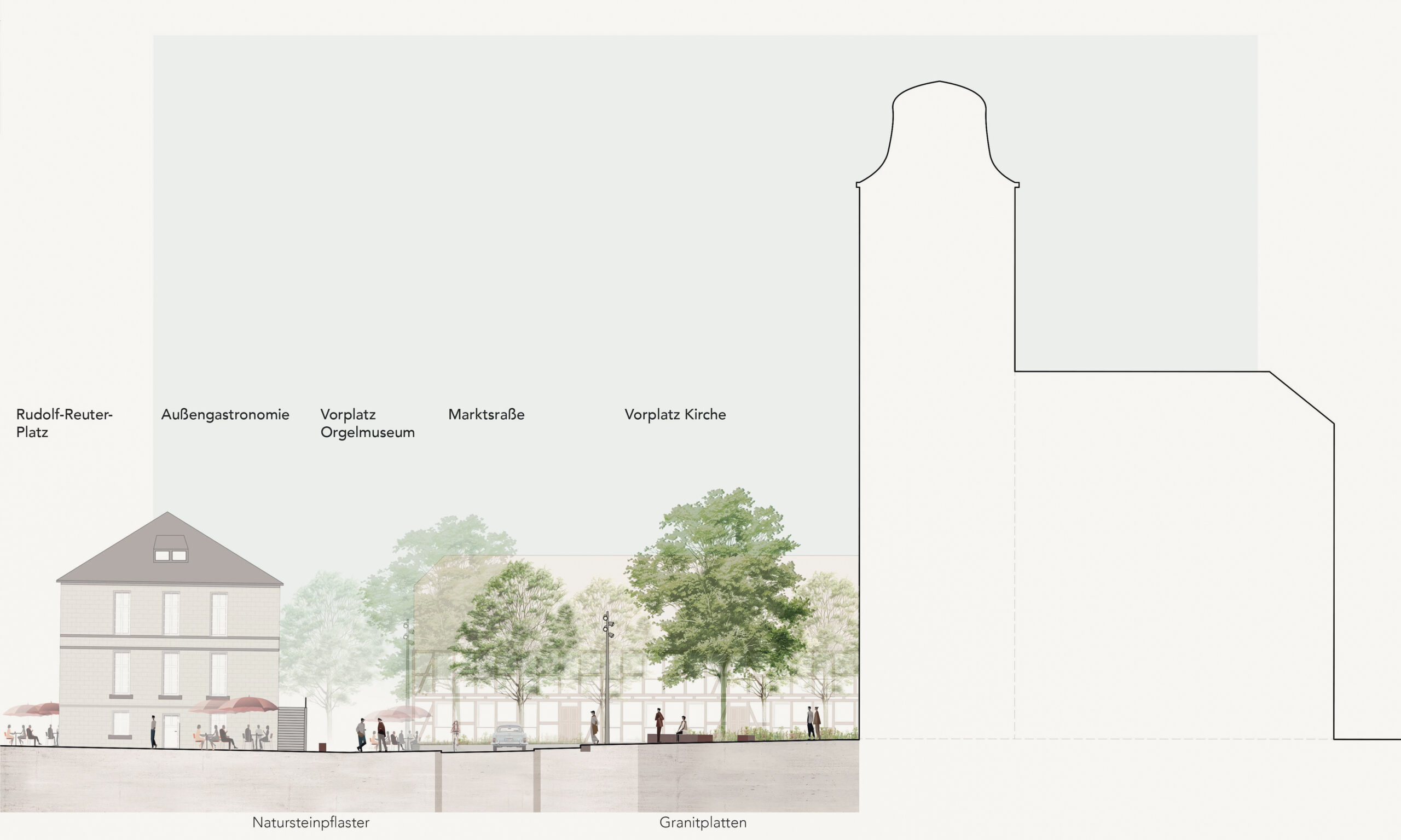
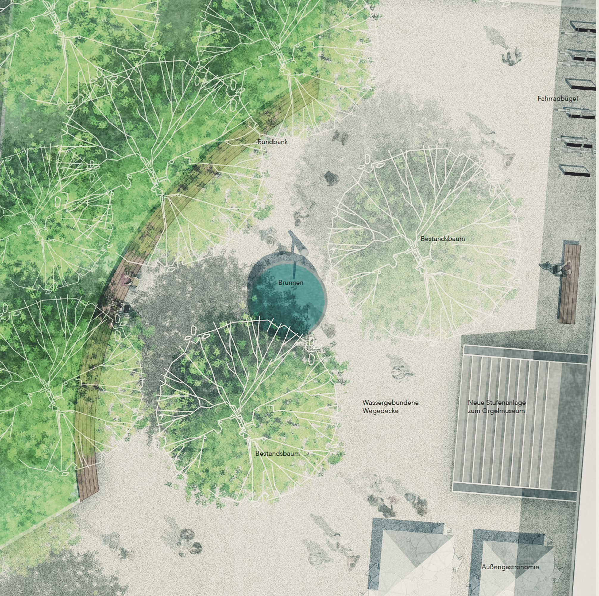
By slightly reducing the width of the carriageway in favour of the open space, a large, appropriate area is created in front of the organ museum. The space can be used as a place to stay and for catering. Large benches, some with backrests, will be placed around the existing tree in the centre of the square to create a spacious recreation area. The tree is integrated into the paved square with an open tree disc. A space for markets and festivals will be created around the central element to enliven the city centre square. The square will be furnished discreetly and appropriately for the location.
The furniture is made from certified wood and regionally produced materials to avoid long delivery routes. Passing the organ museum on the side, you reach the third area. The green frame also surrounds this area with a lush green back. The square will have a water-bound path surface with light-coloured litter, setting it apart from the central town square in terms of design and giving it its own identity. The existing trees will also be integrated into the new square in order to create large crowns with appropriate shade. A fountain enlivens the small square and provides a pleasant soundscape. The catering facilities are distributed around three sides of the organ museum and thus enliven the adjacent open spaces.
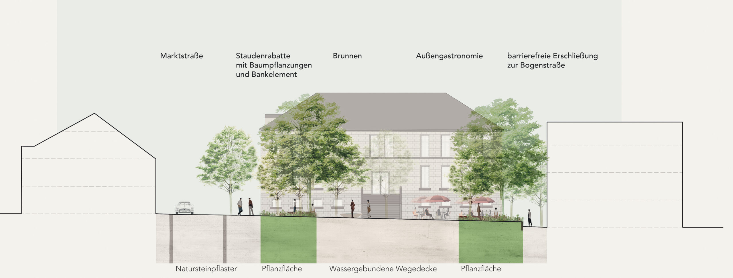
The street space will be massively upgraded with new tree planting. In both Bogenstraße and Marktstraße, the existing motif of the row of trees will be supplemented and completed by new plantings. This will give the street an important green atmosphere. Climate trees suitable for the new challenges in the urban climate will be planted. All new tree plantings will have a tree trench in which the rainwater from the pavements and the street will be collected and seeped away. At the same time, additional water is available to the tree in the event of prolonged drought. The existing tree plantings will be given an open, planted tree disc. The road cross-section will be reduced slightly to create more space for the peripheral areas. The width required for buses to pass each other will be maintained. This will create more space for pedestrians and stationary traffic and give the trees enough room to grow. The new trees will noticeably improve the urban climate, as the shade they cast will reduce the heating of the paved areas and any water that accumulates will be retained in the green areas, where it can seep away and evaporate. The market street will be marked by a low kerb and an open drainage trough.
The redesign gives Bogenstrasse an open, green character. The rainwater that accumulates here runs into the green tree discs of the single-row tree planting, where it can seep away and evaporate. The carriageway itself is only discreetly defined by marker nails. The pavement extends across the entire open space and creates a generous road space in which all road users are equally entitled to use.
Parking spaces for bicycles and cars are created between the tree plantings. Additional seating elements invite people to linger and enliven the street space. The lighting supports the design concept with different intensities. The street lighting will be continued as in the existing design. The new central town square between the church and the museum will also be given special lighting, which will make the new square a single entity even in the twilight and evening hours. The church garden and Rudolf-Reuter-Platz will be fitted with more discreet bollard luminaires.
The design concept, proportions and furnishings are intended to emphasise the character of the small town square. Robust, green and multifunctional, it will be available to residents as a new centre in the future.
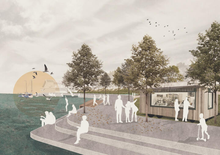
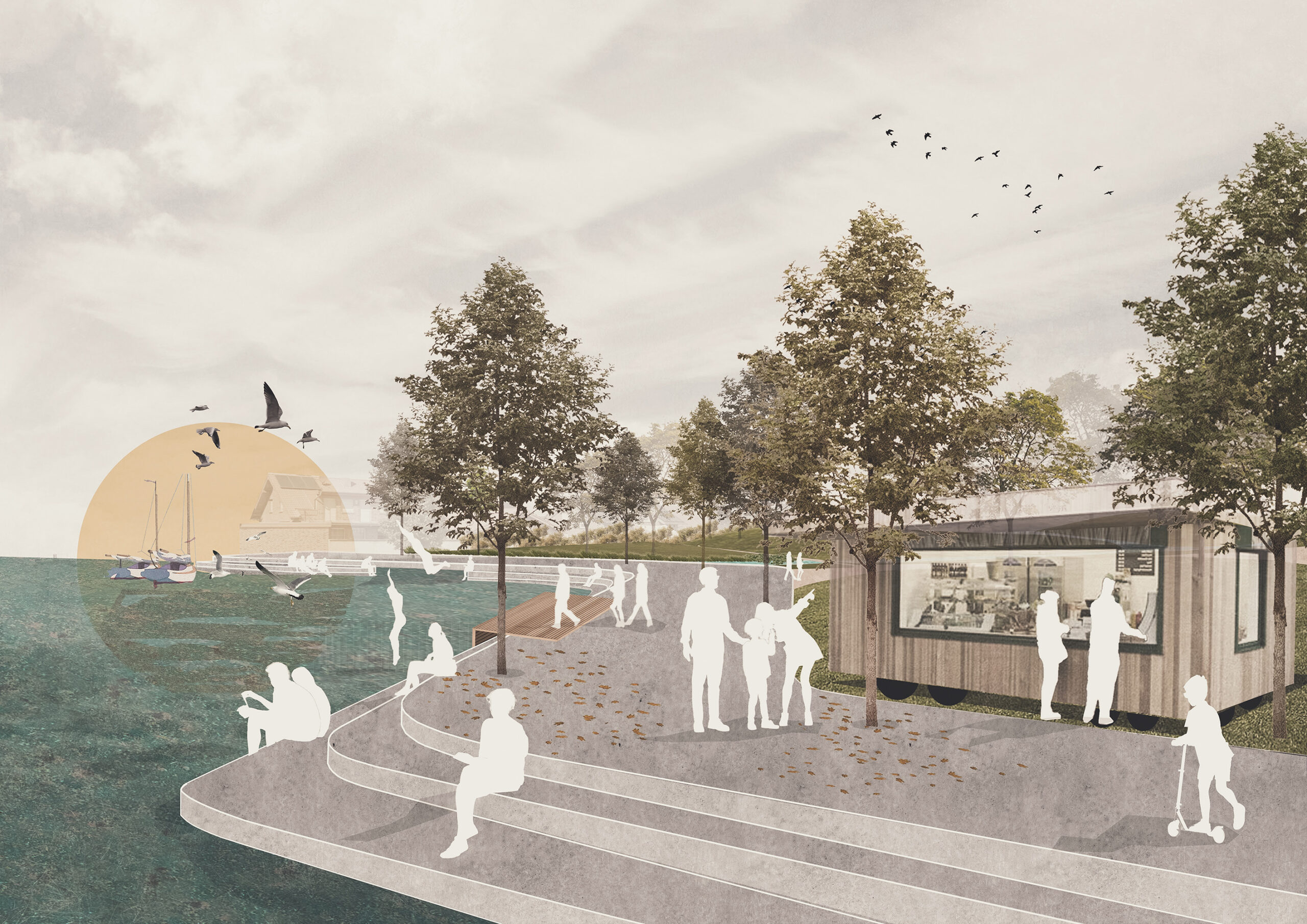
En route to the lake | Inden-Schophoven
3. Prize | En route to the lake
Inden-Schophoven
Inden Schophoven’s new green heart.
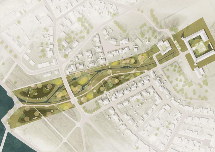
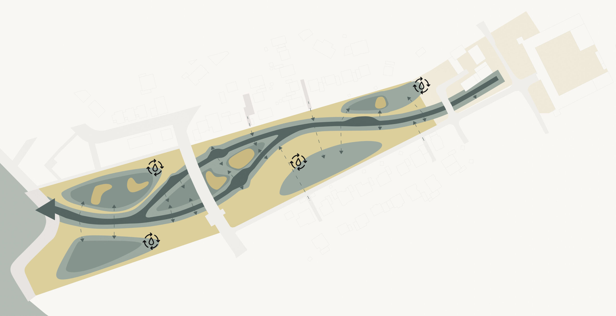
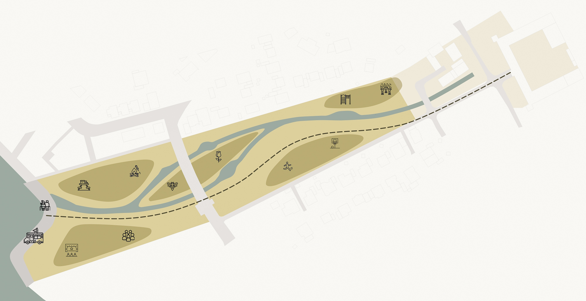
Open space concept ❘ Over the coming years the entire surrounding area is due to undergo major transformation. An expansive industrial zone, currently inaccessible, will give way to an extensive recreational area with a lake, and this will be made accessible to the public. This will mean a radical change too for Inden Schophoven. This transformation offers a huge opportunity for sustainable development, since the whole region will not only be facing substantial demands due to the change in utilisation, but also climate change. Our design responds to both these key factors. The future park will become part of the region’s tourism concept and at the same time provide a sustainable local recreation area with blue-green infrastructure, while also creating a vista stretching from the Müllenark estate to the lake. Alongside the design for the park, the Müllenark estate will also be incorporated into the project. Here, in future, the focus will be on tourism with the creation of a green inner courtyard incorporating comfortable seating areas for both gastronomy and hotel guests.
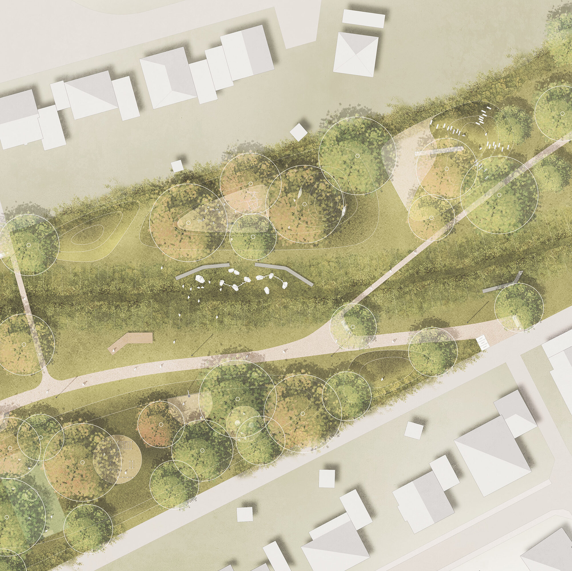
The blue-green ribbon ❘ The park stretches from the Müllenark estate to the edge of the future lake. A meandering path connects these two places in a natural way. The path is flanked by a similarly curved retention basin, which splits as it reaches the lake, forming an island. The concept envisages not only the collection, infiltration and evaporation of rainwater within the park grounds, but also channelling rainwater from the surrounding publicly accessible areas into the park and then into the retention basin. Following heavy rainfall, this will create a watercourse leading into the lake. During periods of normal rainfall, individual puddles will form within the trough thus producing constant fluctuation between a water-bearing depression and a dry, utilisable hollow. A selection of resilient plants emphasises precisely these features. In addition to the central depression, some of the remaining areas are also slightly deepened, so they too can serve as retention areas during periods of heavy rainfall.
Modelling ❘ The entire park area is modelled according to these demands and uses, with the principal aim of ensuring all materials remain on site. Excavated spoil from the depression will be employed to form small hills for play and relaxation, or landscaped with plants. The new island will also use this spoil to form it and build it up. Here, intensive greening complete with nesting and nourishing shrubs and insect hotels provides a refuge for animals.
Resources and planting ❘ In selecting materials, emphasis has been placed on the responsible use of resources. Great importance is attached to ensuring short supply routes, using local materials and CO2-neutral forms of production. The extent of paved areas is deliberately kept to a minimum. It is only the meandering paths and the access routes through the park that have a water-permeable surface, whereby the top layer is strewn with a local gravel mix. The area next to the lake will be paved in keeping with the overall plan for the lake promenade. The steps in front are made of prefabricated concrete elements, providing an attractive place to linger right by the water. Furniture and play equipment in the park will be manufactured from certified, durable wood. Planting in the park is deliberately varied, with intensively planted areas alternating with open lawns and meadows. Towards the periphery, areas become more intensively planted. Not only do the various tree types stand closer together, they are also underplanted with shrubs. These are nourishing shrubs and thus provide habitats for animals. In selecting the plants, careful thought has been given to species diversity and sustainability, with a view to increasing biodiversity in the park.

Promenade and transition to lake ❘ The development of Site 2, located between Schlichstrasse and the future lake, will take place in several stages. In the next few years, the existing completely greened shielding wall will be preserved. This area will only be accessible via a simple network of paths. The meandering path through the park, leading from the Müllenark estate continues as a smaller path over the shielding wall and terminates in a viewing platform from which visitors can trace the area’s evolution – from open-cast mine to lake – on display boards highlighting this transformation. Two temporary areas on the shielding wall itself, invite visitors to linger under the trees. To mark the access to the emerging park, troughs already extend under the road as far as the embankment, so rainwater can be captured directly. In order to later merge these two sites into a single park and to create both a visual axis and a hydraulic engineering connection from the Müllenark estate to the lake, the existing shielding wall will be demolished.
Schlichstrasse ❘ A zebra crossing is being installed so that visitors can cross Schlichstrasse safely and move easily between one side of the park and the other.
Lighting concept ❘ Lighting is designed to structure the night-time atmosphere and ensure visitors’ safety. Dark corners and potential danger spots will be illuminated. This will encourage people to use the park during the evening hours and help create a feeling of security. To prevent vandalism, a sufficient number of high mast lights will be provided at regular intervals equipped with energy-saving LED luminaires, which not only protect the environment, but also reduce running costs. Park lighting is also designed to be respectful of the surroundings and prevent any disturbance to wildlife.
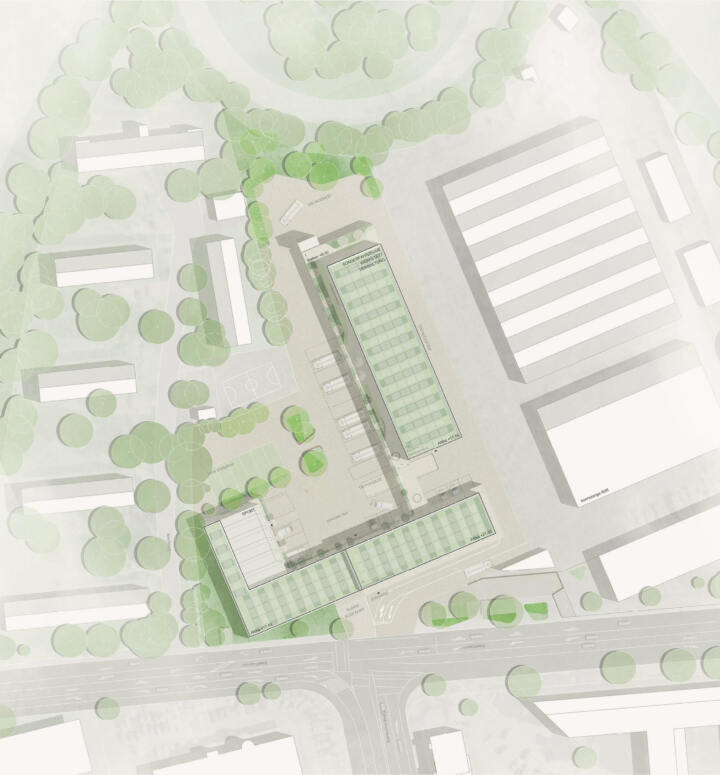
Workshops Ferdinand-von-Steinbeis-School | Tuttlingen
Recognition | Workshops Ferdinand-von-Steinbeis-School
Tuttlingen
In Collaboration with Atelier 30, Kassel
The open space of the new workshop building of the Ferdinand-von-Steinbeis School creates a lively, green school campus that combines meeting zones with seating and recreation areas, exercise areas and access routes. The central green spaces create self-contained areas in which there is an active area with table tennis tables and plenty of seating, a quiet area with a large work table under a pergola and a communicative lounge area. At the same time, the green spaces loosen up the stone break area and improve the microclimate.
The open space concept supports an educational environment that is designed for collaborative learning, movement and communication. The versatile areas and seating options promote outdoor activities, encourage movement and provide space for communal learning and relaxation during breaks.
The concept also takes various user needs into account and seamlessly integrates barrier-free access and disabled parking spaces into the design. The inner courtyard also offers a play zone with a basketball court, which serves as an active leisure area for pupils during the breaks.
Large, resilient climate trees and a planted pergola create shaded areas in which the summer heating of the areas is reduced. The green areas are designed to form small hollows in which rainwater can collect, evaporate and seep away. Hardy plants that can withstand both long periods of drought and heavy rainfall contribute to the forward-looking, modern design of the school campus.
In order to minimise the paved area, the areas for stationary traffic are paved with grass paving to allow rainwater to seep away on site.

Marketplace | Herten
Recognition | Marketplace
Herten
In collaboration with LK Argus GmbH, Kassel
Concept
The new Herten market square is set off by generous green spaces, which are intended to maximise the greening of the previously stone car park. The adjacent urban park and green spaces are taken up and brought further into the city centre. By means of elongated bench elements, a raised substrate structure and thus a greening by trees on the underground car park is made possible. Despite the new layout, the space remains manageable and invites people to browse and linger. Despite this intensive greening, sufficient open space remains for the established weekly markets and other events.
Antoniusstraße is largely freed from traffic and extends the existing pedestrian zone. This will allow the street space to be used by cafés, restaurants and other businesses. A shady row of trees, numerous seating options and bicycle stands create an attractive extension of the city centre with a high quality of stay.
Mobility
The future design of Herten’s market square was developed against the backdrop of climate change, the changing understanding of mobility and the numerous user requirements for public spaces. The concept is characterised by a high standard of amenity and a shift of stationary traffic to directly adjacent areas.
The aim is to reduce motorised traffic within the area to a minimum in order to create a generous open space offering plenty of room for the market, active uses and undisturbed recreational opportunities. Consequently, the square and the neighbouring streets are to be designated as a pedestrian zone, which can only be used by delivery and market traffic at walking speed for a limited period of time. Contrary to the announcement, only seven parking spaces will be created within the area in the southern section, as the formulated requirements for conflict-free traffic organisation, design, greenery and quality of stay of the future market square cannot be reconciled with its use as a car park and counteract the necessary conversion and its objectives.
In addition, the car parks on Kurt-Schumacher-Straße, the underground car park under the market square, which will be renovated, and the Vitusstraße car park, which will be extended in the future, provide sufficient parking space within walking distance. These pedestrian connections will be qualitatively linked to the city centre thanks to their increased attractiveness. In the future, parking space management should make it possible to shift more stationary traffic and, for example, accommodate long-term parkers in the underground car park. The creation of bicycle parking facilities at the individual retail locations and a central facility with weather protection, charging infrastructure for pedelecs and parking spaces for special bicycles will improve the accessibility of the market square for other modes of transport and promote active mobility. In addition, the pedestrian connection to the ‘Kurt-Schumacher-Straße’ bus stop will be upgraded.
The tactile guiding strip in the existing area will also be extended and enable barrier-free access to the market square, Antoniusstraße and the neighbouring alleyways.
Green and open spaces
The market square is almost completely underbuilt by the existing underground car park. Despite these structural conditions and the associated limited possibilities, all square and street spaces follow the principle of the sponge city.
Rainwater should remain on site as far as possible, be available to the planting areas and also be used for evaporative cooling via open troughs. The mix of green and paved areas also offers a wide variety of places to stay and play. Various meeting and recreation areas for young and old will be created on the market square, which will be structured by intensively planted green areas. Large, valuable existing trees will be preserved and supplemented with new plantings. This makes them an important building block for a sustainable city centre and its open spaces. The overall appearance of the market square is supported by a slight topographical elevation of the green areas, which allows the square to be planted despite the underground car park and at the same time creates a varied space.
Material
The new market square is characterised by light-coloured, robust floor coverings that give the city centre a modern appearance. Visually, the areas for the weekly market and the church are set on a natural stone carpet in a Roman pattern, creating a mixture of tradition and modernity. The rest of the market square and the neighbouring alleyways will have a robust, low-maintenance concrete paving, similar to the new paving in Ewaldstraße.
The parking spaces outside the underground car park will be made of grass paving so that the water can seep away directly and the areas will have a near-natural appearance. In the future, these can be removed and the neighbouring green areas extended.
Furnishing
Two central play areas and numerous seating elements liven up the square and provide a variety of places to spend time. Sufficient bicycle racks will be placed along all access routes, including for cargo bikes and e-bikes.
Pole-mounted luminaires will be installed across the square, each with several light points. These will be aligned in such a way that the main areas of the square are specifically illuminated. In this way, light pollution and excessive energy consumption can be avoided. A uniform design and colour concept is chosen for all elements of the square furniture.

Moritz quarter | Büren
2nd Prize | Moritz quarter
Büren
Concept
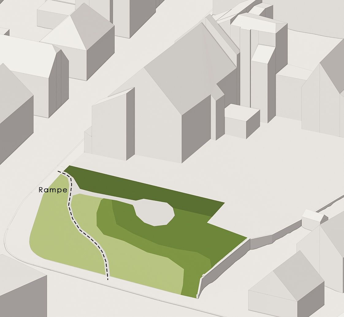
The demolition of several buildings will create a new urban square that will serve as a valuable addition to other open spaces in Büren’s city centre and form a new urban oasis. This square not only offers recreational areas, but also enhances the ecological quality of the urban environment. This will create an appealing space in the immediate vicinity of the historic Mauritius Grammar School.
Thanks to the new arrangement of the car parking spaces behind the police building, the green space of the square can be further extended. This leads to a continuous connection to Judengasse and at the same time creates a new, attractive route in a north-south direction.
Moritzplatz
Moritzplatz primarily presents itself as a generous, green space that offers numerous opportunities to spend time within the surrounding green areas. A small area with a café is being created in the centre of the square, while another square is located directly on Bertholdstrasse. Following the natural gradient, seating steps are laid out that gently blend into the lawns, creating an exciting contrast to the soft, curved lawn. To the west, the lines of the seating steps blend seamlessly with the existing wall and harmoniously connect the new structures with the old ones.
In the centre of the square, the low, accessible greenery creates an inviting atmosphere, while the edges are bordered by shrub and perennial plantings. This emphasises the open centre and visually separates the square from the surrounding buildings.
Walkway
A path leads along the existing wall over steps, which serves as a new north-south connection and leads directly to Judengasse. A barrier-free path starts further east and also leads via the central square to the connecting path. The average gradient is 4.5%, creating a comfortable, intergenerational place to pass through and spend time.
The small Moritzplatz on Bertholdstrasse serves as the entrance to the new green area in the Moritz neighbourhood. Seating on benches and steps will be created here, inviting people to linger and meet.
Residence
A pavilion can be erected below the police building with two sides directly adjacent to the central square. This pavilion offers sufficient space for outdoor seating for café use and provides a limited view of the police building and the car park behind it. Instead, it directs the view towards the new connection to Judengasse.
Planting
The intensive greening creates a small urban oasis that meets both the requirements of modern city centre open spaces and the challenges of the changing climate. Rainwater can seep away and evaporate directly on the large green areas, while large trees provide shade and thus prevent the paved areas from heating up. These trees are carefully selected to ensure that they can withstand long dry spells in summer.
Judengasse
In Judengasse, all areas previously intended for stationary traffic will be removed. This creates a more generous open space, which is enhanced by high-quality materials and thus loses its previous backyard character. The concept of bands of seating steps is continued here and skilfully bridges the differences in height. This makes the space appear larger and brighter, while at the same time creating new planting areas that emphasise the modern appearance and create a green link to Moritzplatz.
A small square with a seating edge and a shady tree will be created from Königsstraße. This creates a more open and visible entrance to Judengasse. Here too, the seating steps offer space for people to linger and meet.
By eliminating the car parking spaces, the garage rooms can be repurposed, for example as a bicycle workshop. New, covered bicycle parking spaces are also planned.
Materials
The design with the striking seating steps is created using natural stone blocks, some of which are provided with wooden supports as set elements. The two small squares consist of a water-bound path surface surrounded by a border of small stone paving. All path surfaces are made of natural stone paving to ensure barrier-free access. The adjoining footpaths, as well as the Judengasse and the access road to the car park, will be paved with concrete blocks in a colour that matches the natural stone surfaces. The car parks themselves are made of grass paving so that the water can seep away directly and the areas have a near-natural appearance.
Lighting
Pole-mounted luminaires will be installed across the square, each containing several light sources. These are specifically aligned to optimally illuminate the main areas of the square. This minimises light pollution and reduces energy consumption.

New Fire and Rescue Station I | Bonn
2nd Prize | New Fire and Rescue Station I
Bonn
In collaboration with Steimle Architekten
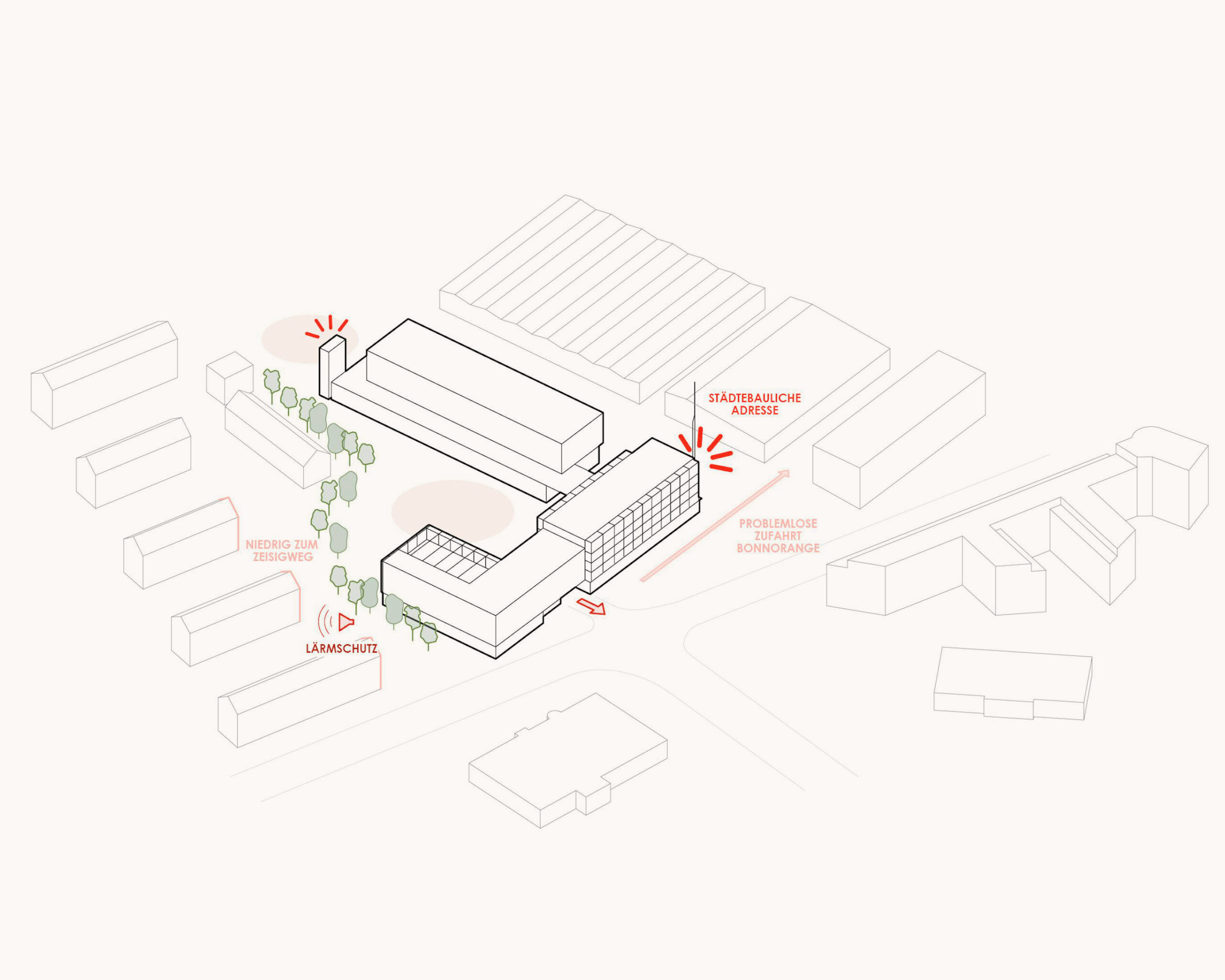
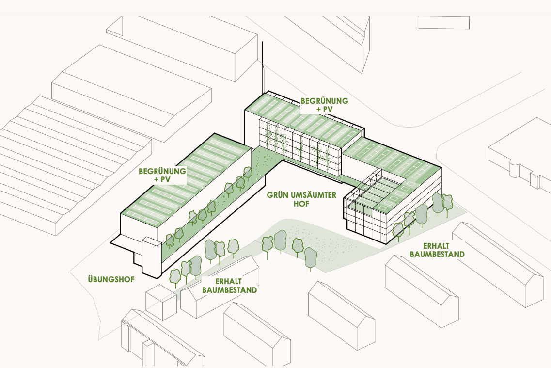
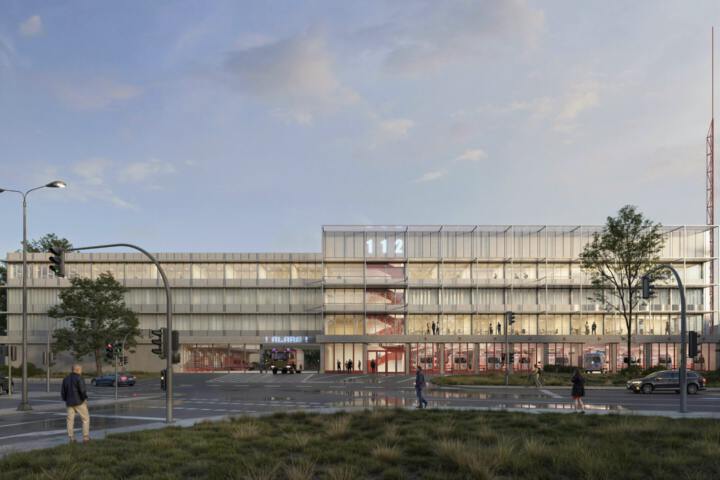
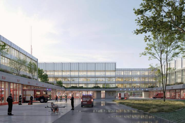
The new Fire and Rescue Station I in Bonn consists of an ensemble of three vibrant building blocks that form a shared courtyard. The vehicle hall bases enclose the alarm courtyard, while on the upper floors a green terrace connects the modular building sections and invites visitors to linger.
The ensemble asserts itself independently in its context and transforms the existing urban fragmentation into a clear structure. The building maximises parking space and faces Lievelingsweg, showcasing its uses as a fire station, rescue station, control centre and administrative building. Towards the motorway in the north, the training tower rises characteristically and functionally above the training courtyard. The residential development on Zeisigweg is protected from an urban planning perspective by the low building and shielded from noise by the setting. Towards Lievelingsweg, the main building rises clearly recognisable as an important address in the urban space. This is underlined by the radio antenna to the east of the control centre.
The architecture reflects its use as a public building. It shows the population both its function as a helping and protective building. The expression of the building is independent and appropriate for a fire station. The chosen architectural form gives the building a face on all sides.
Open space
A fire station is primarily a highly functional building that must ensure intuitive and conflict-free operational and work processes. The outdoor facilities are therefore largely occupied by parking areas and turning circles.
Open space with green areas and recreational facilities is therefore provided on the first floor. A surrounding terrace band, facing the inner courtyard, creates a green setting that is also visible from the courtyard, thus creating a pleasant atmosphere on both levels. The eastern terrace, above the vehicle hall, offers various recreational options in addition to greenery.
The terraces on the south and west sides are slightly narrower, but can also be accessed via the building.
The uppermost roof areas are constructed as retention roofs with extensive greenery in combination with photovoltaics. This is an important component in terms of rainwater management, as the courtyard areas are equipped with heavy-duty surfaces that are not expected to allow infiltration.
In the inner courtyard, there is a central area that remains free of access roads and turning circles. This will be a green island with large trees. The use of tree trenches could be useful here. In addition, the north façade of the west wing will be covered with ground-based façade greening. The parking space for repair vehicles will be located north of this façade. A permeable construction method may be conceivable here.
The fire station shares the access area and emergency exit with the BonnOrgange access area.
The parking deck of the regional waste disposal company will also be accessed via this entrance. The remaining space will be used to accommodate the necessary visitor parking spaces and bicycle parking spaces.
When selecting materials, CO2-neutral production, the use of regional building materials and recyclability, etc. must be taken into account.
In terms of colour, lighter but non-glare shades are to be preferred, as these absorb less radiant heat, which would otherwise be released back into the ambient air by dark surfaces.
The trees along the western boundary of the property will be preserved as far as possible. For the benefit of the neighbouring buildings, the green strip will be sensibly supplemented and densified after the construction work. When selecting trees and shrubs, care must be taken to ensure that they are resistant to the changed conditions at the site, such as extreme summer temperatures, periods of drought, heavy rainfall, etc. In addition, care must be taken to provide nutrient-rich trees and shrubs within the planting areas, as well as nesting and breeding opportunities to promote biodiversity.